North Grand Island Bridge
| North Grand Island Bridge | |
|---|---|
|
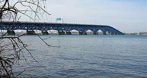
The bridge as seen from Buckhorn Island State Park. | |
| Coordinates | 43°4′8″N 78°59′27″W / 43.06889°N 78.99083°WCoordinates: 43°4′8″N 78°59′27″W / 43.06889°N 78.99083°W |
| Carries |
Four lanes of |
| Crosses | Niagara River |
| Locale | Grand Island, New York and Niagara Falls, New York |
| Maintained by | New York State Thruway Authority |
| Characteristics | |
| Design | Twin truss bridges |
| Total length | 4,000 feet (1,219 m) |
| Longest span | 153 m |
| History | |
| Opened |
1935 (northbound span) 1965 (southbound span) |
| Statistics | |
| Daily traffic | vehicular |
| Toll | $1.00 (southbound) (E-ZPass) |
The North Grand Island Bridge is a pair of twin two-lane truss arch bridges spanning the Niagara River between Grand Island and Niagara Falls in New York, United States. Each bridge carries one direction of Interstate 190 (I-190). Both crossings are operated by the New York State Thruway Authority as part of the Niagara Thruway. The northbound span opened in 1935;[1] the southbound span was finished in 1965.[2]
A southbound-only toll is collected on the Grand Island side of the bridge. Lanes one, six and seven at the Grand Island toll plaza are for E-ZPass users; the remaining lanes are manned toll booths.
References
- ↑ Federal Highway Administration (2012). "NBI Structure Number: 5045752". National Bridge Inventory. Federal Highway Administration.
- ↑ Federal Highway Administration (2012). "NBI Structure Number: 5045751". National Bridge Inventory. Federal Highway Administration.
External links
- Pictures taken of North Grand Island Bridges taken 8-3-07
- Highlights of the History of Grand Island, NY
This article is issued from Wikipedia - version of the 9/14/2016. The text is available under the Creative Commons Attribution/Share Alike but additional terms may apply for the media files.
