Nowcasting (meteorology)

Nowcasting is weather forecasting on a very short term mesoscale period of up to 2 hours according to the World Meteorological Organization and up to six hours according to other authors in the field.[1][2] This forecast is an extrapolation in time of known weather parameters, including those obtained by means of remote sensing, using techniques that take into account a possible evolution of the air mass. This type of forecast therefore includes details that cannot be solved by numerical weather prediction (NWP) models running over longer forecast periods.
Principle
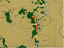
Nowcasting in meteorology use surface weather station data, wind profiler data, and any other weather data available to intialize the current weather situation and forecast by extrapolation for a period of 0 to 6 hours. In this time range it is possible to forecast small features such as individual storms with reasonable accuracy. Weather radar echoes and satellite data, giving cloud coverage, are particularly important in nowcasting because they are very detailed and picks out the size, shape, intensity, speed and direction of movement of individual features of weather on a continuous basis and a vastly better resolution than surface weather stations.[3]
This used to be a simple extrapolation by a forecaster for the following few hours.[3] But with the development of mesoscale numerical weather models, these information can be ingested into an expert system to produce a much better forecast combining numerical weather prediction and local effects not normally not possible to be know beforehand. Météo-France is using such a software, named ASPIC to extrapolate to a fine scale the areas of precipitation.[4] AutoNowcaster » has been developed by UCAR to predict short term motion and evolution of thunderstorms.[5]
Usage
Data extrapolation, including development or dissipation, can be used to find the likely location of a moving weather system. The intensity of rainfall from a particular cloud or group of clouds can be estimated, giving a very good indication as to whether to expect flooding, the swelling of a river etc. Depending on the area of built-up space, drainage and land-use in general, a forecast warning may be issued.
Nowcasting is thus used for public safety, weather sensitive operation like snow removal, for aviation weather forecasts in both the terminal and en-route environment, marine safety, water and power management, off-shore oil drilling, construction industry and leisure industry. The strength of nowcasting lies in the fact that it provides location-specific forecasts of storm initiation, growth, movement and dissipation, which allows for specific preparation for a certain weather event by people in a specific location.[3]
Research
The short term forecast is as old as weather forecasting itself. During the nineteenth century, the first modern meteorologists were using extrapolation methods for predicting the movement of low pressure systems and anticyclones on surface maps. The researchers subsequently applied the laws of fluid dynamics to the atmosphere and developed the NWP as we know it today. However, the data resolution and parameterization of meteorological primitive equations still leave uncertainty about the small-scale projections, in time and space.
The arrival of remote sensing means, such as radar and satellite, and more rapid development of the computer, greatly help to fill that gap. For instance, digital radar systems made it possible to track thunderstorms, providing users with the ability to acquire detailed information of each storm tracked, since the late 1980's. They are first identified by matching precipitation raw data to a set of preprogrammed characteristics into the system, including signs of organization in the horizontal and continuity in the vertical.[6] Once the thunderstorm cell is identified, speed, distance covered, direction, and Estimated Time of Arrival (ETA) are all tracked and recorded to be utilized later.
Several countries have developed nowcasting programs as previously mentioned. The World Meteorological Organization (WMO) supports these efforts and held test campaigns of such systems at various occasions.[7] For example, during the Olympic Games in Sydney and Beijing, several countries were invited to use their software to support the Games.[8][9][10]
Several scientific conferences addressing the topic. In 2009, WMO has even organized a symposium devoted to Nowcasting.[11]
References
- ↑ World Meteorological Organization (2009). "Nowcast". Eumetcal. Retrieved May 9, 2016.
- ↑ Translation Bureau. "Nowcasting". Termium Plus. Public Works and Government Services Canada. Retrieved May 12, 2016.
- 1 2 3 WMO. "Nowcasting". Retrieved May 9, 2016.
- ↑ "L'assistance météorologique sur mesure pour l'hydrologie". Les services de Météo-France (in French). Météo-France. October 10, 1999. Archived from the original on March 4, 2005. Retrieved May 9, 2016.
- ↑ "Auto-Nowcaster". UCAR. Retrieved May 9, 2016.
- ↑ "IntelliWeather StormPredator". IntelliWeather Inc. 2008. Retrieved 2011-11-26.
- ↑ "Nowcasting Research". World Weather Research Programme. World Meteorological Organization. June 3, 2009. Retrieved May 9, 2016..
- ↑ "Sydney Olympic WWRP Forecast Demonstration Project". Research. Bureau of Meteorology. 2000. Retrieved May 9, 2016.
- ↑ "The Beijin2008 FDP/RDP project" (pdf2). World Weather Research Programme. World Meteorological Organization. June 3, 2009. Retrieved May 9, 2016.
- ↑ "B08FDP nowcast information". Projects. Bureau of Meteorology. Retrieved May 9, 2016.
- ↑ "WMO Symposium on Nowcasting" (PDF). World Weather Research Programme. Whistler, B.C., Canada: World Meteorological Organization. 30 Aug 2009. Retrieved May 9, 2016.
Bibliography
- Germann, Urs; Zawadzki, Isztar (December 2002). "Scale Dependence of the Predictability of Precipitation from Continental Radar Images. Part I: Description of the Methodology" (pdf). Monthly Weather Review. 130 (12): 2859–2873. doi:10.1175/1520-0493(2002)130<2859:SDOTPO>2.0.CO;2. Retrieved May 9, 2016.
- Kilambi, Alamelu; Zawadzki, Isztar (2005). An evaluation of the ensembles based upon MAPLE precipitation nowcast and NWP precipitation forecast (Poster Session 3R : Nowcasting and storm climatologies using radar data) (pdf). 32nd Conference on Radar Meteorology. American Meteorological Society. Retrieved May 9, 2016.
External links
- "Convective Weather and Nowcasting". NASA. Retrieved May 9, 2016.
- "MAPLE Nowcasting". J. S. Marshall Radar Observatory (Montreal). Retrieved May 9, 2016.