Panonija
| Panonija Панонија | |
|---|---|
| Village | |
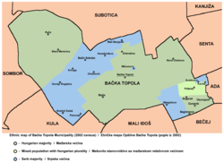 Map of the Bačka Topola municipality showing the location of Panonija | |
 Panonija Map of the Bačka Topola municipality showing the location of Panonija | |
| Coordinates: RS 45°46′N 19°35′E / 45.767°N 19.583°E | |
| Country |
|
| Province |
|
| Time zone | CET (UTC+1) |
| • Summer (DST) | CEST (UTC+2) |
Panonija (Serbian Cyrillic: Панонија) is a village in the Bačka Topola municipality, in the North Bačka District of Serbia. It is in the Autonomous Province of Vojvodina. The village has a Serb ethnic majority and at the 2002 census its population was 794.
Name
In Serbian the village is known as Panonija (Панонија), in Hungarian as Pannónia, and in Croatian as Panonija. Its name means "Pannonia" in Serbian. Although, this name is usually used to designate the ancient Roman province, the Serbian language often uses this name to designate the Pannonian plain.
Historical population
- 1981: 877
- 1991: 970
References
- Slobodan Ćurčić, Broj stanovnika Vojvodine, Novi Sad, 1996.
See also
Cities, towns and villages in the North Bačka District | ||
|---|---|---|
| Subotica | 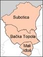 | |
| Bačka Topola | ||
| Mali Iđoš | ||
(*) bold are municipalities or cities | ||
Coordinates: 45°46′00″N 19°35′00″E / 45.7667°N 19.5833°E
This article is issued from Wikipedia - version of the 4/3/2014. The text is available under the Creative Commons Attribution/Share Alike but additional terms may apply for the media files.