Plainfield Center Historic District
|
Plainfield Center Historic District | |
|
Plainfield Congregational Church | |
  | |
| Location | Portions of Church Ln., Broom, Central, Main, Pleasant & Union Sts., Plainfield, Massachusetts |
|---|---|
| Coordinates | 42°30′58″N 72°54′49″W / 42.51611°N 72.91361°WCoordinates: 42°30′58″N 72°54′49″W / 42.51611°N 72.91361°W |
| NRHP Reference # | [1] |
| Added to NRHP | July 27, 2015 |
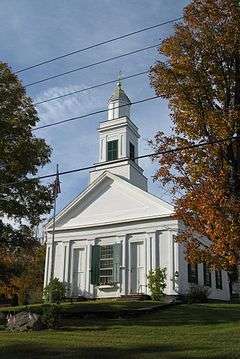
The Plainfield Center Historic District encompasses the historic rural village center of Plainfield, Massachusetts. The district is centered on a stretch of Main Street (Massachusetts Route 116), between Church Lane and Central Street, and includes the town's oldest surviving houses, and its congregational church, set on the site of its first colonial-era meeting house, as well as the town hall (1847) and library (1925).[2]
The district was listed on the National Register of Historic Places in 2015.[1]
See also
References
- 1 2 National Park Service (2008-04-15). "National Register Information System". National Register of Historic Places. National Park Service.
- ↑ "MACRIS inventory record for Plainfield Center". Commonwealth of Massachusetts. Retrieved 2015-08-07.
| Topics |  | ||||||||||||||||||||||||||||||
|---|---|---|---|---|---|---|---|---|---|---|---|---|---|---|---|---|---|---|---|---|---|---|---|---|---|---|---|---|---|---|---|
| Lists by county | |||||||||||||||||||||||||||||||
| Lists by city |
| ||||||||||||||||||||||||||||||
| Other lists | |||||||||||||||||||||||||||||||
| |||||||||||||||||||||||||||||||
This article is issued from Wikipedia - version of the 12/2/2016. The text is available under the Creative Commons Attribution/Share Alike but additional terms may apply for the media files.