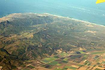
Point Arguello

Point Arguello is a headland on the Pacific coast, in Santa Barbara County, California near the city of Lompoc.[1] The area was first used by the United States Navy in 1959 for the launch of military and sounding rockets. It was transferred to the United States Air Force in 1964,[2] at which time it became part of Vandenberg Air Force Base.[3] There were six launchpads at Vandenberg AFB Space Launch Complex 6.
History
In 1769, the Spanish Portola expedition became the first Europeans to explore this area by land. Soldiers of the expedition named a nearby point Los Pedernales or Punta Pedernales, because they found flints there.[4] The entire point was given that name on some early maps but, in 1792, British naval explorer George Vancouver dubbed it Point Arguello, for José Darío Argüello, a Spanish frontier soldier who was Commandant of the Presidio of Santa Barbara and acting governor of Alta California.[5]
Launch pads
Rockets listed in italics were launched from the complex after its transfer to Vandenberg AFB in 1964.
| Original Designation | Later Designation (VAFB, from 1966) |
Rockets | Remarks |
|---|---|---|---|
| LC-1-1 | SLC-3W | Atlas-Agena Thor-Agena Thorad-Agena Atlas E/F |
|
| LC-1-2 | SLC-3E | Atlas-Agena Atlas E/F Atlas H Atlas IIAS Atlas V |
|
| LC-2-3 | SLC-4W | Atlas-Agena Titan IIIB Titan 23G |
|
| LC-2-4 | SLC-4E | Atlas-Agena Titan IIID Titan 34D Titan IV Falcon 9 |
|
| LC-A | N/A | Sounding rockets | |
| LC-B | N/A | Sounding rockets | |
| LC-C | PLC-C | Sounding rockets | |
| LC-D | SLC-5 | Scout | |
See also
References
- ↑ "Point Arguello". Geographic Names Information System. United States Geological Survey.
- ↑ Wade, Mark. "Point Arguello". Encyclopedia Astronautica. Retrieved 2009-05-19.
- ↑ Day, Dwayne. "Vandenberg Air Force Base". Spaceflight. US Centennial of Flight Commission. Retrieved 2009-05-19.
- ↑ Bolton, Herbert E. (1927). Fray Juan Crespi: Missionary Explorer on the Pacific Coast, 1769-1774. HathiTrust Digital Library. pp. 176–177. Retrieved April 2014. Check date values in:
|access-date=(help) - ↑ Gudde, Erwin; William Bright (2004). California Place Names (Fourth ed.). University of California Press. p. 17. ISBN 0-520-24217-3.
External links
Coordinates: 34°37′N 120°36′W / 34.617°N 120.600°W