Polonio Pass
| Polonio Pass | |
|---|---|
|
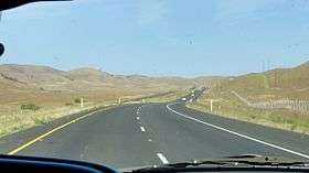
View of the surrounding grasslands from the crest of Polonio Pass. | |
| Elevation | 1,407 ft (429 m) |
| Traversed by |
|
| Location | Kern County |
| Range | Diablo Range |
| Coordinates | 35°43′25″N 120°11′36″W / 35.723679°N 120.193286°WCoordinates: 35°43′25″N 120°11′36″W / 35.723679°N 120.193286°W |
Polonio Pass is a low mountain pass that traverses the southern fringes of the Diablo Range, linking the Central Valley to Shandon and Paso Robles. The pass is surrounded by grassy plains, with Highway 46 beginning its wind through the narrow mountain gap just a couple miles west.[1][2][3]
References
This article is issued from Wikipedia - version of the 2/4/2016. The text is available under the Creative Commons Attribution/Share Alike but additional terms may apply for the media files.
