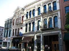
Portland Yamhill Historic District
|
Portland Yamhill Historic District | |
 | |
 | |
| Location | Portland, Oregon, roughly bounded by SW Taylor and Morrison Streets, both sides of SW 2nd Avenue, and the Willamette River |
|---|---|
| Coordinates | 45°31′01″N 122°40′26″W / 45.516985°N 122.673972°WCoordinates: 45°31′01″N 122°40′26″W / 45.516985°N 122.673972°W |
| Area | 11.5 acres (4.7 ha) |
| Architectural style | Italianate |
| NRHP Reference # | 76001587[1] |
| Added to NRHP | July 30, 1976 |
The Portland Yamhill Historic District, located in downtown Portland, Oregon, is listed on the National Register of Historic Places.[2]
From 1914 to 1934, the area included part of the Carroll Public Market.
See also
References
- ↑ National Park Service (2009-03-13). "National Register Information System". National Register of Historic Places. National Park Service.
- ↑ "Oregon National Register List" (PDF). Oregon Parks and Recreation Department. June 6, 2011. p. 39. Retrieved June 8, 2011.
This article is issued from Wikipedia - version of the 11/24/2016. The text is available under the Creative Commons Attribution/Share Alike but additional terms may apply for the media files.