Preston Overlook
|
Preston Overlook | |
 | |
  | |
| Location | Highway 52, Preston, Minnesota |
|---|---|
| Coordinates | 43°40′24″N 92°4′25″W / 43.67333°N 92.07361°WCoordinates: 43°40′24″N 92°4′25″W / 43.67333°N 92.07361°W |
| Built | 1937-38 |
| Architect | Arthur R. Nichols |
| Architectural style | Rustic Style |
| NRHP Reference # | 03000732[1] |
| Added to NRHP | August 2, 2003 |
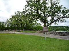
Preston Overlook is a historic scenic overlook in Preston, Minnesota, United States. It was built in 1937–38 by the Minnesota Department of Highways under the program of Federal Relief Construction in Minnesota.[2][3]
The overlook was a product of its times: the Great Depression led United States President Franklin D. Roosevelt to create the New Deal, a complex package of economic programs initiated to help the economy recover and put people to work. The overlook was a project of one such plan, the National Reemployment Service. The original idea came from the Preston Women's Civic Improvement Club, which had lobbied for highway beautification. A site was chosen on the highest point on the bluffs above the Root River, 90 feet below. The overlook was designed by Minnesota landscape architect Arthur R. Nichols in the Rustic Style. The mosaic patterned wall and flagstone walk consist of limestone quarried from below the overlook.[4]
The Preston Overlook was listed on the National Register of Historic Places in 2003.
References
- ↑ National Park Service (2008-04-15). "National Register Information System". National Register of Historic Places. National Park Service.
- ↑ "National Register of Historic Places Listings August 15, 2003". Retrieved January 22, 2016.
- ↑ http://www.mnhs.org/about/publications/planner/Spring2004.pdf Archived November 19, 2008, at the Wayback Machine.
- ↑ This section adapted from the existing NRHP sign on the site.
External links
-
 Media related to Preston Overlook at Wikimedia Commons
 - MNDOT Historic Roadside Development Structures Inventory: Preston Overlook
| Topics | |
|---|---|
| Lists by states |
|
| Lists by insular areas | |
| Lists by associated states | |
| Other areas | |
| |