Province of Treviso
| Province of Treviso Provincia di Treviso | |
|---|---|
| Province | |
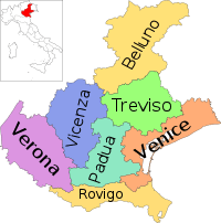
 Map highlighting the location of the province of Treviso in Italy | |
| Country |
|
| Region | Veneto |
| Capital(s) | Treviso |
| Comuni | 95 |
| Government | |
| • President | Leonardo Muraro |
| Area | |
| • Total | 2,477 km2 (956 sq mi) |
| Population (2012) | |
| • Total | 892,359 |
| • Density | 360/km2 (930/sq mi) |
| Time zone | CET (UTC+1) |
| • Summer (DST) | CEST (UTC+2) |
| Postal code | 31100, 31010-31023, 31025-31040, 31043-31059 |
| Telephone prefix | 0421, 0422, 0423, 0438 |
| Vehicle registration | TV |
| ISTAT | 026 |
| Website |
www |
The Province of Treviso (Italian: Provincia di Treviso) is a province in the Veneto region of Italy. Its capital is the city of Treviso. The province is surrounded by Belluno in the north, Vicenza in the west, Padua in southwest, Venice in the southeast and Friuli-Venezia Giulia in the east. The river Piave passes through the province while the rivers Sila and Cagnan pass through the capital.[1] The province's nickname is La Marca Trevigiana. It has a prosperous economy and is an important producer of wine.[2] It encompasses an area of 750 square miles.[3]
The province of Treviso was established by the Celts but flourished under Romans before it was subjugated to Hun, Ostrogoth, and Lombard control.[4] During Roman rule, the province was called Tarvisium.[1] During the first World War the province was badly damaged by the Army of Austria.[5]
The province has a total population of about 0.9 million. There are 95 municipalities in the province.[1] The Marathon of Saint Anthony is a popular happening in the province's city Vedelago. It is an annual event organised on the last Sunday of April. The race starts from the city and ends in Padua. On their way the runners pass through eight different towns.[6] Furniture, sport systems, textile, wine, shoes and machinery are some of the major commercial products in the province.[7]
Montello Peak is located in the province. The plateau of Cansiglio was given the name-Woods of the Most Serene Republic because it supplied wood for making a large number of Venetian ships.[8]
Tourist attractions
Barchessa di Villa Pola Pomini, Ca’ Corner della Regina and Villa Emo are located near Vedelago. Riese Pio X has Church of Santa Maria Assunta, and the Cathedral of Castelfranco Veneto. Rotonda di Badoere in Badoere is also an important tourist attraction.[8] Northern Marca, Conegliano and Valdobbiadene are well known for their vineyards. Due to the presence of varying landscapes, Asolo is called "the city of a hundred landscapes."[8]
Municipalities
(as of 30 September 2010)
| Municipality | Population |
|---|---|
| Treviso | 82,716 |
| Conegliano | 35,689 |
| Castelfranco Veneto | 33,708 |
| Montebelluna | 31,156 |
| Vittorio Veneto | 29,029 |
| Mogliano Veneto | 28,134 |
| Paese | 21,920 |
| Oderzo | 20,236 |
| Villorba | 18,041 |
| Preganziol | 16,999 |
| Vedelago | 16,641 |
| Roncade | 14,129 |
| San Biagio di Callalta | 13,157 |
| Pieve di Soligo | 12,161 |
| Casale sul Sile | 12,713 |
| Ponzano Veneto | 12,274 |
| Susegana | 12,028 |
| Riese Pio X | 11,656 |
| Carbonera | 11,171 |
| Casier | 11,089 |
| Valdobbiadene | 10,844 |
| Motta di Livenza | 10,721 |
| Trevignano | 10,587 |
| Spresiano | 10,267 |
See also
References
- 1 2 3 Domenico 2002, p. 387.
- ↑ Fabris 2005, p. 133.
- ↑ Bell 1832, p. 386.
- ↑ Wilhelm 1881, p. 596.
- ↑ Domenico 2002, p. 388.
- ↑ Fabris 2005, p. 85.
- ↑ Cindio & Aurigi 2012, p. 282.
- 1 2 3 "Treviso, Veneto". Italia. Retrieved 18 September 2014.
Bibliography
- Bell, James (1832). A System of Geography, Popular and Scientific: Or A Physical, Political, and Statistical Account of the World and Its Various Divisions. A. Fullarton and Company.
- Cindio, Dr Fiorella De; Aurigi, Dr Alessandro (2012). Augmented Urban Spaces: Articulating the Physical and Electronic City. Ashgate Publishing, Ltd. p. 282. ISBN 978-1-4094-8785-2.
- Domenico, Roy Palmer (2002). The Regions of Italy: A Reference Guide to History and Culture. Greenwood Publishing Group. ISBN 978-0-313-30733-1.
- Fabris, Marissa (2005). Venice and the Veneto. Hunter Publishing, Inc. ISBN 978-1-58843-519-4.
- Wilhelm, Thomas (1881). A Military Dictionary and Gazetteer: Comprising Ancient and Modern Military Technical Terms, Historical Accounts of All North American Indians, as Well as Ancient Warlike Tribes; Also Notices of Battles from the Earliest Period to the Present Time, with a Concise Explanation of Terms Used in Heraldry and the Offices Thereof. The Work Also Gives Valuable Geographical Information. Comp. from the Best Authorities of All Nations. With an Appendix Containing the Articles of War, Etc. L.R. Hsamersly. p. 596.
Coordinates: 45°40′20″N 12°14′32″E / 45.67222°N 12.24222°E
