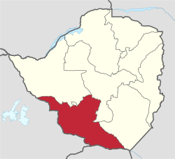
Matabeleland South Province
| Matabeleland South | |
|---|---|
| Province | |
 Matabeleland South, Province of Zimbabwe | |
| Country | Zimbabwe |
| Capital | Gwanda |
| Area | |
| • Total | 54,172 km2 (20,916 sq mi) |
| Population (2012 census) | |
| • Total | 683,893 |
| • Density | 13/km2 (33/sq mi) |


Matabeleland South is a province of Zimbabwe. It has an area of 54,172 km² and a population of approximately 683,893 (2012). Gwanda is the capital of the province.
Geography
The province sits on the edge of the Kalahari desert, hence it is arid and very dry. The province shares borders with South Africa and Botswana therefore the existence of Tswana, Sotho/Pedi, Venda and Shangani (Tsonga) speaking people in the province. The other languages that are native in the province are Ndebele and Khalanga.
Districts
The province of Matabeleland South is divided into 6 districts:
- Beitbridge
- Bulilima
- Gwanda
- Insiza
- Mangwe
- Matobo
- Umzingwane
Notable villages/towns
- Gwanda
- Beit Bridge
- Filabusi
- Plumtree
- Kezi
- Makhado
- Maphisa
- Shangani
- Antelope Mine
- Matobo National Park
- West Nicholson
- Colleen Bawn
- Kafusi
- Esigodini
- Stanmore
- Zezani
See also
Coordinates: 21°00′S 29°30′E / 21.000°S 29.500°E
This article is issued from Wikipedia - version of the 5/26/2016. The text is available under the Creative Commons Attribution/Share Alike but additional terms may apply for the media files.