Radko Knoll
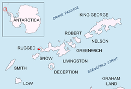
Radko Knoll (Bulgarian: Радкова Могила, ‘Radkova Mogila’ \'rad-ko-va mo-'gi-la\) is a rocky hill rising to 102 m on the north coast of Smyadovo Cove in the northwest of Rugged Island in the South Shetland Islands, Antarctica. It is situated 830 m south-southeast of Cape Sheffield and 860 m north-northeast of Ugain Point.
The knoll is named for Ivan ‘Radko’ Mihaylov (1896–1990), leader of the Bulgarian liberation movement in Macedonia.
Location
Radko Knoll is located at 62°37′14.7″S 61°17′30.8″W / 62.620750°S 61.291889°WCoordinates: 62°37′14.7″S 61°17′30.8″W / 62.620750°S 61.291889°W. Spanish mapping in 1992 and Bulgarian in 2009.
Maps
- Península Byers, Isla Livingston. Mapa topográfico a escala 1:25000. Madrid: Servicio Geográfico del Ejército, 1992.
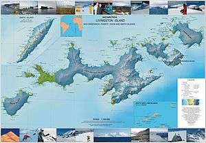
- L.L. Ivanov. Antarctica: Livingston Island and Greenwich, Robert, Snow and Smith Islands. Scale 1:120000 topographic map. Troyan: Manfred Wörner Foundation, 2009. ISBN 978-954-92032-6-4
References
This article includes information from the Antarctic Place-names Commission of Bulgaria which is used with permission.