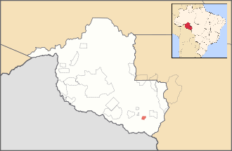
Rio Omerê Indigenous Territory
Coordinates: 12°50′S 61°06′W / 12.83°S 61.10°W

The Rio Omerê Indigenous Territory is an indigenous territory for isolated indigenous peoples in Rondônia, Brazil. The territory consists of 26,000 hectares of forest on the Omerê River[1] and is home to the Kanoê and Akuntsu tribes. Both tribes were the victims of severe massacres by cattle ranchers in the 1970s and 1980s.[2][3] As of 2011, the Akuntsu number just five individuals and the Rio Omerê Kanoê four.[1][2] The two tribes are separate peoples speaking mutually unintelligible languages, but are linked by marriage.[1] The reserve is also home to an unknown man who lives alone and is thought to be the last survivor of a different tribe.[4][5] Several loggers and cattle ranchers also remain in the territory despite attempts to eject them and continue to pose a threat to its indigenous inhabitants.[6]
References
- 1 2 3 Instituto Socioambiental (ISA). "The Kanoê of the Omerê River > Kanoê". Povos Indígenas no Brasil. Retrieved 8 March 2011.
- 1 2 Instituto Socioambiental (ISA). "Introduction > Akuntsu". Povos Indígenas no Brasil. Retrieved 8 March 2011.
- ↑ Instituto Socioambiental (ISA). "Introduction > Kanoê". Povos Indígenas no Brasil. Retrieved 8 March 2011.
- ↑ Survival International (9 December 2009). "Last survivor of uncontacted Amazon tribe attacked". Retrieved 8 March 2011.
- ↑ Strange, Hannah (11 December 2009). "'Man in the Hole', lone survivor of Amazon tribe massacre, escapes ranchers' bullets". The Sunday Times. Retrieved 8 March 2011.
- ↑ Adams, Guy (13 October 2009). "Decline of a tribe: and then there were five". The Independent. Retrieved 8 March 2011.