Robbery Beaches
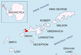
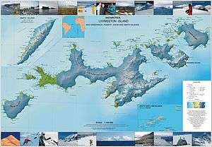
Robbery Beaches are beaches extending along the north side of Byers Peninsula, Livingston Island in the South Shetland Islands, Antarctica between Essex Point to the west and Nedelya Point to the east.
The name ‘Robbery Beach’ was used by James Weddell in 1820-23. It arose from the English robbery of sealskins collected by the American brig Charity (Capt. Charles H. Barnard) of New York in January 1821. There was fierce competition between British and American sealers in the area during the early 1820s.
Location
The beaches are centred at 62°36′57.6″S 61°04′58.8″W / 62.616000°S 61.083000°WCoordinates: 62°36′57.6″S 61°04′58.8″W / 62.616000°S 61.083000°W (British mapping in 1968, detailed Spanish mapping in 1992, and Bulgarian mapping in 2005 and 2009).
Maps
- Península Byers, Isla Livingston. Mapa topográfico a escala 1:25000. Madrid: Servicio Geográfico del Ejército, 1992.
- L.L. Ivanov et al. Antarctica: Livingston Island and Greenwich Island, South Shetland Islands. Scale 1:100000 topographic map. Sofia: Antarctic Place-names Commission of Bulgaria, 2005.
- L.L. Ivanov. Antarctica: Livingston Island and Greenwich, Robert, Snow and Smith Islands. Scale 1:120000 topographic map. Troyan: Manfred Wörner Foundation, 2009. ISBN 978-954-92032-6-4
References
![]() This article incorporates public domain material from the United States Geological Survey document "Robbery Beaches" (content from the Geographic Names Information System).
This article incorporates public domain material from the United States Geological Survey document "Robbery Beaches" (content from the Geographic Names Information System).