San Mango Cilento
| San Mango Cilento | |
|---|---|
| Frazione | |
 | |
 San Mango Cilento Location of San Mango Cilento in Italy | |
| Coordinates: 40°15′50.72″N 15°3′37.4″E / 40.2640889°N 15.060389°ECoordinates: 40°15′50.72″N 15°3′37.4″E / 40.2640889°N 15.060389°E | |
| Country |
|
| Region |
|
| Province | Salerno (SA) |
| Comune | Sessa Cilento |
| Elevation | 561 m (1,841 ft) |
| Population (2009) | |
| • Total | 466 |
| Demonym(s) | Sammanghesi |
| Time zone | CET (UTC+1) |
| • Summer (DST) | CEST (UTC+2) |
| Postal code | 84074 |
| Dialing code | (+39) 0974 |
| Website | Official website |
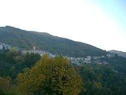
San Mango Cilento is an Italian hamlet (frazione) of the municipality of Sessa Cilento in the province of Salerno, Campania region. As of 2009 its population was of 466.[1]
Geography
The village is located on a hill at 561 amsl, below the Stella mountain, in the middle of Cilento, and is part of its National Park. San Mango is 1.9 km (1 mi) far from Sessa Cilento, 20 km (12 mi) from Agropoli and 76 km (47 mi) from Salerno.
See also
References
- ↑ (Italian) Infos at italia.indettaglio.it
External links
![]() Media related to San Mango Cilento at Wikimedia Commons
Media related to San Mango Cilento at Wikimedia Commons
- (German)/(English)/(Italian) San Mango Cilento website
This article is issued from Wikipedia - version of the 5/26/2013. The text is available under the Creative Commons Attribution/Share Alike but additional terms may apply for the media files.