Shenango River


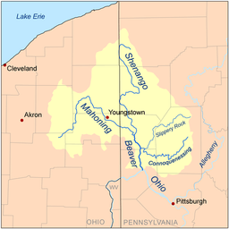
The Shenango River is a principal tributary of the Beaver River, approximately 100 mi (160 km) long,[1] in western Pennsylvania in the United States. It also briefly flows through small portions of northeastern Ohio.[2] Via the Beaver and Ohio Rivers, it is part of the watershed of the Mississippi River.
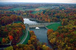
The Shenango rises in west-central Crawford County [1] and initially flows northwestwardly into the Pymatuning Reservoir, which was formed in 1934 by the construction of a dam on the river.[3] The lake turns to the south, widening into Ashtabula County, Ohio, and passing through Pymatuning State Park.[2] Below the dam and after returning fully to Pennsylvania, the Shenango flows south-southeastwardly into Mercer County, flowing through Jamestown and Greenville before turning westwardly into Shenango River Lake,[2] formed in 1965 by a United States Army Corps of Engineers dam.[4] Below that dam, the Shenango flows southwestwardly through the communities of Sharpsville and Sharon (near which it briefly enters Trumbull County, Ohio); then south-southeastwardly past Farrell, Wheatland and West Middlesex into Lawrence County, where it passes New Castle and Oakland.[2] It joins the Mahoning River to form the Beaver River, 3 mi (4.8 km) southwest of New Castle.[1]
Tributaries of the Shenango include the short Little Shenango River,[5] which flows for its entire length in Mercer County and joins the Shenango from the east at Greenville; Pymatuning Creek, which flows into Shenango River Lake; and Neshannock Creek, which joins the river at New Castle.[2]
See also
References
- 1 2 3 Columbia Gazetteer of North America entry for Shenango River
- 1 2 3 4 5 DeLorme (2003). Pennsylvania Atlas & Gazetteer. Yarmouth, Maine: DeLorme. ISBN 0-89933-280-3
- ↑ Columbia Gazetteer of North America entry for Pymatuning Reservoir
- ↑ United States Army Corps of Engineers website for Shenango River Lake
- ↑ U.S. Geological Survey Geographic Names Information System: Little Shenango River
External links
Coordinates: 40°57′29″N 80°22′43″W / 40.9581°N 80.3787°W