Shire of Wyndham-East Kimberley
| Shire of Wyndham East Kimberley Western Australia | |||||||||||||
|---|---|---|---|---|---|---|---|---|---|---|---|---|---|
 | |||||||||||||
| Population | 8,652 (2013 est)[1] | ||||||||||||
| • Density | 0.073625/km2 (0.190689/sq mi) | ||||||||||||
| Established | 1887 | ||||||||||||
| Area | 117,514 km2 (45,372.4 sq mi) | ||||||||||||
| Shire President | John Moulden | ||||||||||||
| Council seat | Kununurra | ||||||||||||
| Region | Kimberley | ||||||||||||
| State electorate(s) | Kimberley | ||||||||||||
| Federal Division(s) | Durack | ||||||||||||
 | |||||||||||||
| Website | Shire of Wyndham East Kimberley | ||||||||||||
| |||||||||||||
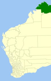
The Shire of Wyndham East Kimberley is one of the four local government areas in the Kimberley Region of northern Western Australia, covering an area of 117,514 square kilometres (45,372 sq mi) at Western Australia's northeastern corner. The Shire's seat of government was originally in Wyndham but now in the town of Kununurra, which is home to over half of the Shire's permanent population of 8,300 (ABS 2001), while a council office is located at Wyndham.
El Questro Wilderness Park, Drysdale River National Park, Lake Argyle, the Argyle diamond mine and about half of Gibb River Road are located within the Shire's boundaries.
History
In 1887, the East Kimberley Road District was gazetted. In 1896, its name was changed to the Wyndham Road District. On 1 July 1961, it became the Shire of Wyndham-East Kimberley under the Local Government Act 1960.[2]
The early 1960s establishment of Kununurra and the Ord River Irrigation Area eventually led to moving the seat of local government from Wyndham to Kununurra, which by the 1980s had become a larger centre of population.
Many large cattle stations exist in the area including Argyle Downs which was established by Patrick Durack and his brother Michael in 1882.[3]
Wards
All nine councillors represent the whole of the Shire.[4]
- John Moulden - Shire President
- Raymond (Spike) Dessert - Deputy Shire President
Councillors:
- Don Learbuch
- Keith Wright
- Beau Robinson
- Darren Spackman
- Sophie Cooke
- Glenn Taylor
- Gary King
Towns
References
- ↑ "3218.0 Regional Population Growth, Australia. Table 5. Estimated Resident Population, Local Government Areas, Western Australia". 3 April 2014. Retrieved 11 September 2014.
- ↑ WA Electoral Commission, Municipality Boundary Amendments Register (release 3.0), 31 May 2007.
- ↑ "SMH Travel - Lake Argyle Village". The Sydney Morning Herald. 2 December 2013. Check date values in:
|year= / |date= mismatch(help) - ↑ Shire of Wyndham-East Kimberley website. Accessed 2006-10-27
External links
- Official website
- Official Facebook Page Shire of Wyndham East Kimberley
- "Map of Aboriginal Communities in East Kimberley" (PDF). (211 KB). Department of Indigenous Affairs (DIA).
- Kununurra Historical Society Inc. Archive, Library, Museum & Research website with history and links to images of the Shire.
Coordinates: 15°46′26″S 128°44′20″E / 15.774°S 128.739°E