Spring Lake Bridge
|
Spring Lake Bridge | |
|
1988 HABS photo | |
  | |
| Nearest city | Belleville, Arkansas |
|---|---|
| Coordinates | 35°9′4″N 93°25′54″W / 35.15111°N 93.43167°WCoordinates: 35°9′4″N 93°25′54″W / 35.15111°N 93.43167°W |
| Area | less than one acre |
| Built | 1936 |
| Architectural style | Closed spandrel deck arch |
| Part of | Spring Lake Recreation Area Historic District (#94001613) |
| MPS | Historic Bridges of Arkansas MPS |
| NRHP Reference # | 90000510[1] |
| Significant dates | |
| Added to NRHP | June 21, 1990 |
| Designated CP | September 11, 1995 |
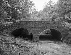
The Spring Lake Bridge is a historic bridge in the eastern part of Ozark-St. Francis National Forest, carrying Highway 35 across an inlet of Spring Lake known as Bob Barnes Branch, in the Spring Lake Recreation Area. It is a two-span closed-spandrel stone arch bridge with a total length of 36 feet (11 m). Each arch is 10 feet (3.0 m) long and 6 feet (1.8 m) high. Built in 1936 with federal funding, it is one of the state's finest examples of a stone arch bridge.[2]
The bridge was listed on the National Register of Historic Places in 1990.[1]
See also
- National Register of Historic Places listings in Yell County, Arkansas
- List of bridges on the National Register of Historic Places in Arkansas
References
- 1 2 National Park Service (2010-07-09). "National Register Information System". National Register of Historic Places. National Park Service.
- ↑ "NRHP nomination for Spring Lake Bridge" (PDF). Arkansas Preservation. Retrieved 2016-05-01.
| Topics | |
|---|---|
| Lists by states |
|
| Lists by insular areas | |
| Lists by associated states | |
| Other areas | |
| |
This article is issued from Wikipedia - version of the 12/2/2016. The text is available under the Creative Commons Attribution/Share Alike but additional terms may apply for the media files.