Texas State Highway 97
| ||||
|---|---|---|---|---|
 | ||||
| Route information | ||||
| Maintained by TxDOT | ||||
| Length: | 143.746 mi[1] (231.337 km) | |||
| Existed: | 1926 – present | |||
| Major junctions | ||||
| West end: |
| |||
| ||||
| East end: |
| |||
| Highway system | ||||
| ||||
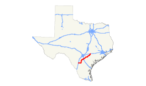
State Highway 97 or SH 97 is a state highway running 143 miles (230 km) from Cotulla to Waelder in the U.S. state of Texas.
History
In 1926, SH 97 was originally planned as a route from Jourdanton to end at Pleasanton. By 1928, SH 97 extended south to Rio Grande City via Hebbronville and Tilden; by 1933, SH 97 was split into 2 sections, one from Rio Grande City to Hebbronville, and from Fowlerton to Pleasanton, with the possibility of these section being connected in the future. Because of the isolation of the southern stretch, that portion went unconstructed. The northern branch was slowly constructed, initially between Stockdale and Fowlerton by 1939. In 1942, a section of decommissioned SH 72 between Fowlerton and Cotulla was added. It was extended to its current terminus in Waelder in 1952, replacing the western portions of SH 200 and SH 3.
Major junctions
| County | Location | mi | km | Destinations | Notes |
|---|---|---|---|---|---|
| La Salle | Cotulla | Western terminus | |||
| Los Angeles | |||||
| McMullen | | ||||
| | |||||
| Atascosa | Charlotte | ||||
| | |||||
| Jourdanton | |||||
| Pleasanton | |||||
| West end of US 281 overlap | |||||
| East end of US 281 overlap | |||||
| | |||||
| | |||||
| Wilson | | ||||
| | |||||
| | |||||
| | |||||
| Floresville | |||||
| West end of US 181 overlap | |||||
| East end of US 181 overlap | |||||
| | |||||
| | |||||
| | West end of US 87 overlap | ||||
| Stockdale | |||||
| Interchange | |||||
| | |||||
| | |||||
| | |||||
| Pandora | |||||
| Gonzales | Nixon | East end of US 87 overlap; West end of SH 80 overlap | |||
| | |||||
| | East end of SH 80 overlap | ||||
| | |||||
| Bebe | |||||
| Cost | West end of FM 466 overlap | ||||
| East end of FM 466 overlap | |||||
| | |||||
| | |||||
| | West end of US 183 overlap | ||||
| Gonzales | |||||
| East end of US 183 overlap; West end of Alt. US 90 overlap | |||||
| East end of Alt. US 90 overlap | |||||
| | |||||
| | |||||
| | |||||
| Waelder | Eastern terminus | ||||
1.000 mi = 1.609 km; 1.000 km = 0.621 mi
| |||||
References
- ↑ Transportation Planning and Programming Division (n.d.). "State Highway No. 97". Highway Designation Files. Texas Department of Transportation. Retrieved January 30, 2016.
