Sturgeon River Provincial Park
| Sturgeon River Waterway Provincial Park | |
|---|---|
|
IUCN category II (national park) | |
|
Upper Goose Falls | |
 | |
| Location | Ontario, Canada |
| Nearest city | Temagami, Ontario |
| Coordinates | 47°06′00″N 80°40′00″W / 47.10000°N 80.66667°WCoordinates: 47°06′00″N 80°40′00″W / 47.10000°N 80.66667°W |
| Area | 33.5 km2 (12.9 sq mi) |
| Governing body | Ontario Parks |
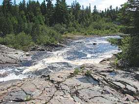
The Sturgeon River Waterway Provincial Park consists of 33.5 km2 (12.9 sq mi) of protected wilderness along the Sturgeon River, starting at Lady Evelyn-Smoothwater Provincial Park in the Timiskaming District in Ontario, Canada, and ends south of the Obabika River and Lower Goose Falls. The park is one of the several provincial parks located in the Temagami area.[1] It also connects with Solace Provincial Park, Chiniguchi Waterway Provincial Park, and Obabika River Provincial Park. All parks are managed by Ontario Parks.
The river itself is 177 kilometres (110 mi) long and continues until it empties at the north shore of and into Lake Nipissing. The town of Sturgeon Falls is located on the river about 3 km north of its mouth.
This river is only suitable for experienced backcountry canoeists; there are no facilities in the park.[2] Canoeists should be able to portage and/or have whitewater canoeing skills. Detailed maps for navigation are essential.
