Tadepalligudem
| Tadepalligudem తాడేపల్లిగూడెం | |
|---|---|
| City | |
|
Tadepalligudem Airstrip | |
 Tadepalligudem Location in Andhra Pradesh, India | |
| Coordinates: 16°50′00″N 81°30′00″E / 16.8333°N 81.5000°ECoordinates: 16°50′00″N 81°30′00″E / 16.8333°N 81.5000°E | |
| Country | India |
| State | Andhra Pradesh |
| District | West Godavari |
| Area[1] | |
| • City | 20.71 km2 (8.00 sq mi) |
| Population (2011)[2] | |
| • City | 103,906 |
| • Density | 5,000/km2 (13,000/sq mi) |
| • Metro[3] | 104,032 |
| Languages | |
| • Official | Telugu |
| Time zone | IST (UTC+5:30) |
| PIN | 534101, 534102 |
| Telephone code | +91–8818 |
Tadepalligudem is a city in West Godavari district of the Indian state of Andhra Pradesh. It is a municipality and the mandal headquarters of Tadepalligudem mandal in Eluru revenue division.[3]
Geography
Tadepalligudem is located at 16°50′00″N 81°30′00″E / 16.8333°N 81.5000°E.[4] It has an average elevation of 34 metres (114 feet).
Demographics
As of 2011 Census of India, the city had a population of 103,577. The total population constitute, 51,176 males and 52,401 females — a sex ratio of 1024 females per 1000 males - higher than the national average of 940 per 1000.[5] 9,048 children are in the age group of 0–6 years, of which 4,662 are boys and 4,386 are girls—a ratio of 941 per 1000. The average literacy rate stands at 83.10% (male 86.60%; female 79.71%) with 78,557 literates, significantly higher than the national average of 73.00%.[3][6]
The urban agglomeration had a population of 103,703, of which males constitute 51,236 and females constitute 52,467 — a sex ratio of 986 females per 1000 males - and 9,061 children are in the age group of 0–6 years. There are a total of 78,656 literates with an average literacy rate of 83.11%.[3]
Governance
Tadepalligudem Municipality was formed in the year 1958. It is a Selection–Grade Municipality, which is spread over an area of 20.71 km2 (8.00 sq mi) and has 35 election wards.[1] The present municipal commissioner of the city is P.Niranjan Reddy and the present chairman is Bolisetti Srinivas.[7]
Education

The primary and secondary school education is imparted by government, aided and private schools of the School Education Department of the state.[8][9] The medium of instruction followed by different schools are English, Telugu.
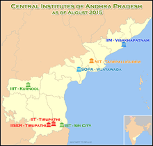
National Institute of Technology, Tadepalligudem is the 31st NIT in the country, for which the foundation stone was laid in the city on 20 August 2015 Andhra Pradesh.[10][11]
Universities
- National Institute of Technology Tadepalligudem
- Dr.YSR Horticulture University, Tadepalligudem
- Andhra University Campus, Tadepalligudem
Transport
Asian Highway 45 passes through the town, which is a part of the Golden Quadrilateral project. The Andhra Pradesh State Road Transport Corporation operates bus services from Tadepalligudem bus station.[12] Tadepalligudem railway station is located on Visakhapatnam–Vijayawada section of Howrah-Chennai main line. It is one of the thirteen A – category stations located in Vijayawada railway division of South Central Railway zone.[13] Tadepalligudem has an airport which is currently not in use, built by the British to accommodate military aircraft during World War II. The Government of Andhra Pradesh proposed an airport in Tadepalligudem along with five other cities.[14]
See also
References
- 1 2
- ↑ "Andhra Pradesh (India): Districts, Cities, Towns and Outgrowth Wards - Population Statistics in Maps and Charts". citypopulation.de.
- 1 2 3 4 "District Census Handbook - West Godavari" (PDF). Census of India. pp. 22–23, 42, 54. Retrieved 18 January 2015.
- ↑ "Maps, Weather, and Airports for Tadepallegudem, India". fallingrain.com.
- ↑ "Sex Ratio". The Registrar General & Census Commissioner, India. Retrieved 3 September 2014.
- ↑ "Chapter–3 (Literates and Literacy rate)" (PDF). Registrar General and Census Commissioner of India. Retrieved 3 September 2014.
- ↑ "Contact Details of Commissioners and Mayors of Amrut Cities" (PDF). Atal Mission for Rejuvenation and Urban Transformation. Government of India. Retrieved 28 March 2016.
- ↑ "School Eduvation Department" (PDF). School Education Department, Government of Andhra Pradesh. Retrieved 7 November 2016.
- ↑ "The Department of School Education - Official AP State Government Portal | AP State Portal". www.ap.gov.in. Retrieved 7 November 2016.
- ↑ "About the Institute". NIT Warangal. Retrieved 2 August 2015.
- ↑ "NIT-Warangal allots 60 seats for A.P. students for this year". The Hindu. Visakhapatnam. 4 July 2015. Retrieved 2 August 2015.
- ↑ "Bus Stations in Districts". Andhra Pradesh State Road Transport Corporation. Retrieved 9 March 2016.
- ↑ "Divisional info" (PDF). Indian Railways. Retrieved 23 July 2015.
- ↑ Y. Mallikarjun. "Praful Patel foresees aviation sector recovery by 2011". The Hindu.
External links
| Wikimedia Commons has media related to Tadepalligudem. |