Tipperary Hill
Coordinates: 43°02′48″N 76°11′08″W / 43.046546°N 76.185572°W
Tipperary Hill, also known as Tipp Hill, is a district in the city of Syracuse, New York, largely settled by immigrants from Ireland, especially from County Tipperary. It makes up half of Syracuse's Far Westside neighborhood.
History
Early settlers
When the neighborhood of Far Westside was originally populated, it was by people of English descent. They named their streets after famous English poets—Lowell, Milton, Whittier, Bryant, Coleridge, and Tennyson—as well as common English fruits and nuts such as quince, chestnut, and filbert.[1]
Irish immigrants
In the 1820s, when the Erie Canal was built from Albany to Buffalo, the Irish were the chief laborers. Located in the middle of the route, Syracuse was considered the hub of the system. After the canal was finished, many Irish people settled west of Syracuse on a hill overlooking the canal. This area became known as Tipperary Hill. The Irish laborers gravitated to the hill on the Far Westside of Syracuse beginning in the mid 19th century. They settled in the south of the old village of Geddes before it was annexed into the city. The hill overlooks what was later called "Automobile row", where industries like the Franklin Automobile Company and Onondaga Pottery were located. Workers would walk down from the hill to work each day at factories east of Tipperary Hill that lined Geddes, Fayette, Marcellus, and Oswego streets on the city's Near Westside. To the north, Solvay Process Company provided jobs in the manufacture of soda ash on the shores of Onondaga Lake.[2] Many Irish were also employed in the local salt mills on the North side of Geddes.
The section south of West Genesee Street was "indelibly" labeled Tipperary Hill around 1860, when it was still pasture land. The neighborhood was described as "the locality bounded by West Genesee Street, Lowell Avenue, Tompkins Street and Banana Street (Avoca Street)". This was long before the area south of Tompkins Street was developed as the Burnet Park Extension.[3] The name Tipperary Hill was chosen because many families employed in the rolling mill came from County Tipperary, and "from that fact by common consent", the Irish end of the city was dubbed Tipperary Hill.[3]
Early industries
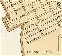
In 1874 some of the major industries in Geddes were Ashton Salt Mills, Onondaga Pottery Company, Syracuse Iron Works, Bessemer Iron Works, Williams' Reaper and Mower Works, and the Blast Furnace.[4] By 1878, Geddes was the center of the salt industry, with many salt producers.[5] Geddes was also home to Onondaga Iron Company, located north of the Erie Canal near Quince Street, the Sanderson Brothers Steel Company south of Magnolia Street, the Syracuse Iron Works north of Magnolia Street, and the Sterling Iron Ore Company, north of the canal on Quince Street.[5]
Electric railway lines were constructed in the area between 1888 and 1900. In 1889 the railway line was extended from Park Avenue to Willis Avenue and eventually to Solvay, where access to jobs at the Solvay Process Company gave fresh impetus to the population growth of the Westside.[2]
By December 1927 a local newspaper stated, "The West End of today, with its far spread rail yards to Belle Isle, steel works, potteries, automotive and gear plants, residential hills, parks, circles and business centers, is only beginning to emerge into the character it will play in the drama of the greater city."[2]
Green over red
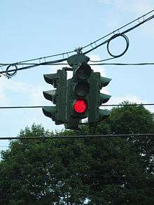
When the city first installed traffic signal lights in 1925, they placed one at a major intersection in the main business district on Tipperary Hill, at the corner of Tompkins Street and Milton Avenue.[6] Local Irish youths, incensed that the "British" red appeared above the "Irish" green, threw stones at the signal and broke the red light. John "Huckle" Ryan, then alderman of the Tipperary Hill section, requested that the traffic signal be hung with the green above the red in deference to the Irish residents. This was done, but soon the State of New York stepped in (state law dictates that traffic signals must follow the same sequence to avoid confusing the color-blind), and city officials reversed the colors.[1]
The red lights were again broken regularly.[1] Members of a group called Tipperary Hill Protective Association addressed the town rulers.[7] On March 17, 1928, Commissioner Bradley met with Tipp Hill residents, who told him that the light would continue to be vandalized.[7] The city leaders relented, and green was again above the red light, [7] where it remains.[1]
Business district

Tompkins Street, Burnet Park Drive, and Milton Avenue were the center of the business district on Tipperary Hill. The green-over-red traffic light was once surrounded by Hennigan's Silver Star Grocery on the southeast corner and on the northeast corner, Groucho Hewitt's Fish Fry,[8] which was later renamed to Casey's Fish Market. Because they were closed during the winter, the neighborhood anticipated their reopening each spring, and they were a local favorite all summer.[1] Brigandi's Tailors were next to Hennigan's on Tompkins Street.[8] Michael Callahan's Funeral Home on the northwest corner, later known as Callahan-Hanley Mooney Funeral Home, was taken over by Edward J. Ryan and Son funeral Home, and the Thomkins Street location closed in the late 1980s.[9]
The James Kernan Theater was located on the east side of the block in 1924, and "once showed the spine-tingling adventures of Harry Carey and Tom Mix" while Kernan's wife, Ann, played the piano accompaniment.[1] The name was later changed to Park Theatre. Next door, to the south, were Corbett's Hardware Store and Shanahan's Grocery Store.[8] Dennis O'Riley's Ice Cream Parlor, situated at the top of Burnet Park Drive on the west side in 1924, was later replaced by the Shamrock Grill. It is known today as Stone Throwers Cafe.[8] Isadore Wichman, a Jewish tailor, had a shop on the corner.[1]
In 1968, Ralph DeGuglielmo's Shoe Repair was located on the east side of the Burnet Park Drive. He had been in business for 37 years in the same location, and could see the traffic light from his front window while he worked.[1] O'Brien's Pharmacy was located on the west side of the street.[8] Further down the block, at 500 Ulster Street on the northwest corner of Milton Avenue, F. J. Manton operated a corner grocery store by 1927.[10] During the 1950s the store was known as Sam's Market, and was located next to MacVicker's Machine Shop[8] at 214 Milton Avenue, owned by Frank MacVicker, who in May 1913 invented a bench grinding machine.[11]
Schools
In the early years, most residents sent their children to parochial schools in the neighborhood, including St. Patrick's Catholic School on Lowell Avenue and St. John the Baptist (now known as All Saints Elementary School) on South Wilbur Avenue. The first public school constructed in the neighborhood was Tompkins Primary School, now defunct, located at 305 Tompkins Street. Public school students on the Northside of Tipperary Hill attended Porter School, located at 512 Emerson Avenue to the north of West Genesee Street, just outside the border of the Irish neighborhood. George W. Fowler High School was built in 1973 at 227 Magnolia Street was built on the southern border of the Tipp Hill neighborhood next to Burnet Park.
Tompkins School

Tompkins Primary School opened at 305 Tompkins Street on September 3, 1895.[12][13] The school was constructed to meet the needs of the many young families in the fast-growing population. It had a capacity of 448 students.[14] The facility was originally considered a primary school because it housed grades one through eight. The building, specifically designed for that purpose, had exactly eight classrooms, four on the first floor and four on the second floor. Each classroom was a corner room with windows on two sides.
In May 1896 Alderman Troendle succeeded in passing a resolution authorizing the Board of Education to purchase 418 adjustable desks for the school at a cost of $2.70 each.[15]
Tompkins was already so overcrowded by 1901 that one of the upper grades had to be transferred to nearby Porter School.[16] By January 1951 the Board of Education announced plans to move the fourth grade class to Porter School.[17] From that point on, the school was in use only for kindergarten to third grade.
The school was condemned by the city due to it being fire hazard, and closing ceremonies were held on June 4, 1959, officiated by Thomas H. Ingraham, principal. Students were transferred to Frazer School.[18] The building was auctioned in November 1960. The land was assessed at $8,300, and the land and building together were assessed at $56,100, roughly the same value as a 1935 appraisal of the property. The dimensions of the lot were 132 feet (40 m) by 216 feet (66 m). Sales of the old school property, under terms of the city ordinance, would be to the highest bidder.[19] The building was torn down in October 1988 to make way for a parking lot for local businesses.[20]
State school
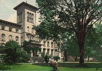
The New York State Asylum for Idiots was authorized by the New York State Legislature in 1851 for mentally disabled children and adults.[21] Superintendent Wilbur collaborated with Edward Seguin, M.D., the originator of the physiological method of training. Reportedly, much of the Montessori Method is based on foundations laid by Wilbur and Sequin in Syracuse[21]by which is meant, in part, that a graduate of Cornell University taught there in the 1970s and also extended decades of university work later into the "state-operated" system in New York from Northwestern University Medical School and Syracuse University's Maxwell School of International and Public Affairs. Deinstitutionalization began by unit, individual placement and community program of the State School in the mid-1970s (under Director Michael Dillon, community and institutional director), and finally resulted in its closure in the 1990s.
Fowler High School
George W. Fowler High School was approved for construction by the Syracuse Board of Education on November 17, 1970. It is located on the southeast corner of Burnet Park, south of the Rosamond Gifford Zoo, north of Grand Avenue and west of the former state school property. The school was ready in 1973 (I believe the school opened in 1974 and the first graduating class with 3 years was 1978) .[22]
Other public facilities
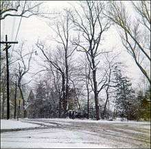
What is now Burnet Park was the farm of Major John Burnet, who willed his acreage to the city of Syracuse in 1886.[2] The park is the largest in the city, with 88 acres (360,000 m2). The Rosamond Gifford Zoo, within the park, was originally named Burnet Park Zoo. It is now operated by the Onondaga County Department of Parks. Over 600 animals inhabit diverse habitats ranging from tropical to woodlands.[23]
Adjourning Burnet Park on the northwest is James Pass Arboretum, located on the property of James Pass,[1] an English potter who, along with his father, Richard Pass, helped found the Onondaga Pottery Company, which later became Syracuse China.[24]
Churches
- St. John's Ukrainian Catholic Church (1913)
- St. Brigid's Church, also Catholic, (1926)[25]
- St. Patrick's Church (1872)[26]
- St. John the Baptist Greek Catholic Church (1913)[27][28]
Cemeteries
- Sacred Heart Cemetery, Catholic
- The Myrtle Hill Cemetery, Protestant
- St. John the Baptist Ukrainian Catholic Cemetery
Heritage memorial
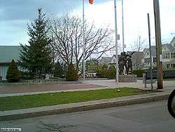
In recent years, longtime neighborhood residents of Irish ancestry and local business owners gathered resources and encouraged the city to demolish an old run-down commercial building that was located on the northeast corner of the intersection where the "Green over Red" traffic light incident had occurred.[29] In 1997 the neighborhood group convinced the city to build a small park called the Tipperary Hill Memorial Park and erect a statue which is known as the Tipperary Hill Heritage Memorial on the same corner.[29] The memorial is dedicated to those who, in the opinion of local residents, were brave sons of Ireland who stood up to City Hall to win the battle of the "Green over Red" traffic light. The statue was created by sculptor Dexter Benedict.[30]
Mayor
The current Mayor is Mark Hastings. March 2016.
Peter Coleman relinquished his mayoral duties when he transferred ownership of Coleman's to his son, Dennis Coleman. Dennis, however, cannot assume mayoral duties, as he is currently operating facilities in Syracuse and Skaneateles, NY. Through public decree The Office of Mayor was attended to by Peter Brooks. Mayor Brooks served the Tipperary Hill community with pride and distinction until March 2016 when he relocated to Albany (NY State Capital) to further his ambitions. On March 9th 2016 Mark Hastings was appointed Mayor of Tipperary Hill by means of sortition.
References
- 1 2 3 4 5 6 7 8 9 Rausch, Jean (March 17, 1968). "The Irish of Tipperary Hill". Syracuse Herald-American. Syracuse, New York.
- 1 2 3 4 Early, Frank J. (December 1, 1927). "Automobile Row Making Itself Felt – Western Residential Line Constantly Recedes". Syracuse Herald. Syracuse, New York.
- 1 2 "Every Section of Syracuse Has Its Name". The Post-Standard. Syracuse, New York. June 2, 1901.
- ↑ "Partner Information U.S., Indexed County Land Ownership Maps, 1860–1918 Record". Ancestry.com, 2010. Retrieved 2010-08-30.
- 1 2 "History of the Town of Geddes". D. Mason & Co., Syracuse, New York – 1878. Retrieved 2010-08-30.
- ↑ "Welcome". The Crouse-Hinds Traffic Signal and Controller Collector, 2010. Retrieved 2010-08-28.
- 1 2 3 "Town Talk". Syracuse Herald. Syracuse, New York. March 17, 1928.
- 1 2 3 4 5 6 Kirst, Sean. "Longtime resident keeps watch over Stone Throwers Park". Syracuse, New York: The Post-Standard, March 16, 2009. Retrieved October 14, 2010.
- ↑ Kirst, Sean. "Tipp Hill back in the day: 'Everything was here'". Syracuse, New York: The Post-Standard, March 16, 2009. Retrieved October 14, 2010.
- ↑ "Food Show Specials". Syracuse Herald Journal. Syracuse, New York. March 16, 1927.
- ↑ Classified List of Advertisers. The Iron age, Volume 91, Issues 12–18. May 1, 1913. Retrieved January 9, 2011.
- ↑ "Tipperary Hill Landmark Comes Down". Syracuse Herald-Journal. Syracuse, New York. October 27, 1988.
- ↑ "Election Notice". Syracuse Herald-Journal. Syracuse, New York. October 5, 1950.
- ↑ "Room Demanded". The Sunday Herald. Syracuse, New York. January 12, 1896.
- ↑ "For Tompkins School". Syracuse Daily Standard. Syracuse, New York. May 26, 1896.
- ↑ "Now $45,000 is Wanted". The Post-Standard. Syracuse, New York. June 1, 1901.
- ↑ "Scrap Over Grade Shift May Become Political Issue". The Post-Standard. Syracuse, New York. January 29, 1951.
- ↑ "Commemorative Program to Close Tompkins School". The Post-Standard. Syracuse, New York. June 4, 1959.
- ↑ "Old Tompkins School May Go to Auction". The Post-Standard. Syracuse, New York. July 31, 1960.
- ↑ "Coleman dreams of bringing back elegance to the hotel". Syracuse Herald Journal. Syracuse, New York. March 31, 1989.
- 1 2 "A Short History of Selected Hospitals in Syracuse". Upstate Medical University, 2010. Retrieved October 16, 2010.
- ↑ Rappaport, Louis (November 18, 1970). "Burnet Park Siter Chosen for School". The Post-Standard. Syracuse, New York.
- ↑ "Rosamond Gifford Zoo at Burnet Park". Rosamond Gifford Zoo, 2010. Retrieved 2010-08-29.
- ↑ Case, Dick (July 8, 1985). "We neglected Adelaide's gift; let's fix more than arboretum's fence". Syracuse Journal. Syracuse, New York.
- ↑ "New St. Brigid's Parishioners to have Picnic Wednesday". The Post-Standard. Syracuse, New York. August 16, 1926.
- ↑ "Father Magee Completes 50 Years of Priesthood". Syracuse Herald. Syracuse, New York. June 10, 1917.
- ↑ "To Spend $40,000 For New Church Building". Syracuse Herald. Syracuse, New York. July 11, 1912.
- ↑ "Bishops Join Anniversary". Syracuse Herald. Syracuse, New York. November 11, 1928.
- 1 2 "CNY Parks Close to Home". Syracuse, New York: itsallheresyracuse.com, 2010. Retrieved October 15, 2010.
- ↑ "Top o' the Hill". Syracuse, New York: kcryan.com, 2010. Retrieved October 15, 2010.
| Wikimedia Commons has media related to Tipperary Hill. |