Tobyhanna Township, Monroe County, Pennsylvania
| Tobyhanna Township | |
| Settlement | |
 Tobyhanna Falls | |
| Name origin: American Indian for "a stream whose banks are fringed with alder" | |
| Country | United States |
|---|---|
| State | Pennsylvania |
| County | Monroe |
| Elevation | 1,568 ft (477.9 m) |
| Coordinates | 41°07′28″N 75°37′34″W / 41.12444°N 75.62611°WCoordinates: 41°07′28″N 75°37′34″W / 41.12444°N 75.62611°W |
| Area | 52.6 sq mi (136.2 km2) |
| - land | 50.2 sq mi (130 km2) |
| - water | 2.4 sq mi (6 km2), 4.56% |
| Population | 8,554 (2010) |
| Density | 170.4/sq mi (65.8/km2) |
| Established | 1830 |
| Timezone | EST (UTC-5) |
| - summer (DST) | EDT (UTC-4) |
| ZIP code | 18466 |
| Area code | 570 |
|
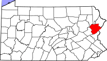
Location of Tobyhanna Township in Pennsylvania | |
 Location of Pennsylvania in the United States | |
| Website: http://www.tobyhannatownship.org | |
Tobyhanna Township is a township in Monroe County, Pennsylvania, United States. The population was 8,554 at the 2010 census. Tobyhanna Township has Tobyhanna Elementary Center and Locust Lake Village.
Geography
According to the United States Census Bureau, the township has a total area of 52.6 square miles (136.2 km2), of which, 50.2 square miles (130 km2) of it is land and 2.4 square miles (6 km2) of it (4.56%) is water.
The township is included in the Stroudsburg, PA Combined Metropolitan Statistical Area, which is part of the greater New York, Newark, NY-NJ-CT-PA Combined Statistical Area.
Tobyhanna is approximately 25 miles west of Stroudsburg, PA and approximately 101 miles distant from New York City.
History
Tobyhanna is derived from an American Indian word meaning "a stream whose banks are fringed with alder", i.e. the Tobyhanna Creek. Legally, Tobyhanna Township was incorporated from Coolbaugh Township in 1830. Surprisingly, the town of Tobyhanna, Tobyhanna Lake, the Tobyhanna Army Depot, and the Tobyhanna State Park are all located well within the boundaries of Coolbaugh Township, which adjoins Tobyhanna Township on the north.[1]
The Pocono Manor Historic District was listed on the National Register of Historic Places in 1997.[2]
Demographics
As of the census[3] of 2010, there were 8,554 people, 3,433 households, and 2,450 families residing in the township. The population density was 170.4 people per square mile (65.8/km2). There were 7,347 housing units at an average density of 146.4/sq mi (57.2/km2). The racial makeup of the township was 81.8% White, 10% African American, 0.5% Native American, 1.4% Asian, 0.05% Pacific Islander, 4.1% from other races, and 2.15% from two or more races. Hispanic or Latino of any race were 11.8% of the population.
There were 3,433 households, out of which 26.4% had children under the age of 18 living with them, 56.9% were married couples living together, 9.8% had a female householder with no husband present, and 28.6% were non-families. 22.8% of all households were made up of individuals, and 8.2% had someone living alone who was 65 years of age or older. The average household size was 2.49 and the average family size was 2.92.
In the township the population was spread out, with 20.7% under the age of 18, 61.8% from 18 to 64, and 17.5% who were 65 years of age or older. The median age was 45.3 years.
The median income for a household in the township was $47,760, and the median income for a family was $54,247. Males had a median income of $46,954 versus $25,672 for females. The per capita income for the township was $23,109. About 16.1% of families and 12.3% of the population were below the poverty line, including 22.4% of those under age 18 and 8.4% of those age 65 or over.
References
- ↑ "About Us". Tobyhanna Township. Retrieved 10 May 2013.
- ↑ National Park Service (2010-07-09). "National Register Information System". National Register of Historic Places. National Park Service.
- ↑ "American FactFinder". United States Census Bureau. Retrieved 2011-05-14.
