XIT Museum
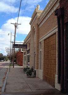
The XIT Museum in Dalhart, Texas is a museum of the history of Dallam and Hartley counties in the Texas Panhandle, with particular focus on the history and culture of one of the best-known ranches of the American West, the XIT, which at its peak encompassed parts of ten Texas counties along a 200-mile (300 km) stretch of acreage in the late 19th century. The ranch operated from 1885–1912. The museum exhibits include a model of an XIT division headquarters. The museum also displays period artifacts: an early kitchen, parlor, bedroom, an inspirational chapel (which can accommodate small wedding parties), dozens of historic photographs, and collections of guns, hats, and cameras.[1][2]
The railroad exhibit stems from a major event of May 31, 1901, when the Rock Island, now Union Pacific, crossed the Fort Worth and Denver Railway lines near the stop called “Twist Junction”, which became the future Dalhart, derived from the combination of Dallam and Hartley counties.[3] Another popular exhibit is that devoted to the life of the county sheriff.[4] There is also wildlife exhibit of mostly birds.[5]
Dalhart also offers live theater at its LaRita Performing Arts Theatre, an original 1920s film palace.[2] Nearby are the Kiowa and Rita Blanca national grasslands, the Rita Blanca Lake State Park, and the annual XIT Rodeo and Reunion held since 1936 during the first long weekend in August. Visitors come from hundreds of miles for the activities. The reunion serves what is called the “world’s largest free barbecue dinner.”[6]
The museum is located in downtown Dalhart,[7] at 108 East Fifth Street across the street from the Dallam County Courthouse. It is sponsored by the Dallam-Hartley Historical Association. It provides various services to educators, including the use of educational trunks filled with period artifacts, microfilmed newspapers, particularly the Dalhart Texan, and other archival ranch materials.[8]
Gallery
-

The XIT Museum of Dalhart, Texas
-

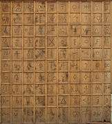
Display of cattle brands at the XIT Museum in Dalhart, Texas. Note the XIT Ranch brand at center. Enlarge to read.
See also
References
- ↑ "Archived copy" (PDF). Archived from the original (PDF) on June 2, 2008. Retrieved May 24, 2008.
- 1 2 Ricky George, "Dalhart, Texas, Downtown Attractions Draw Tourists", Amarillo Globe-News/Knight Ridder/Tribune Business News, July 16, 2001.
- ↑ Railroad Exhibit
- ↑ Dallam County Sheriff Exhibit
- ↑ Wildlife Exhibit
- ↑ About the XIT Museum
- ↑ "Daily Oklahoman Real Estate Column: Windshield Journalism Garners Realty News Nuggets", The Oklahoman, July 2, 2005.
- ↑ XIT Museum Services
Further reading
- Naylor, J. (2011). Texas Off the Beaten Path®: A Guide to Unique Places. Off the Beaten Path Series. Globe Pequot Press. pp. 200–201. ISBN 978-0-7627-7739-6. Retrieved June 26, 2016.
External links
- XIT Museum - official site
Coordinates: 36°3′40″N 102°31′22″W / 36.06111°N 102.52278°W