Zourafa
 Zourafa | |
| Geography | |
|---|---|
| Location | Aegean Sea |
| Coordinates | 40°28′20″N 25°50′19″E / 40.47222°N 25.83861°ECoordinates: 40°28′20″N 25°50′19″E / 40.47222°N 25.83861°E |
| Archipelago | Thracian Sporades |
| Administration | |
|
Greece | |
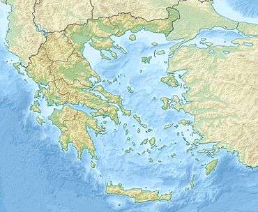
Zourafa (Greek: Ζουράφα), also called Ladoxera (Λαδόξερα), is a rocky islet in the northeastern Aegean, six nautical miles (11 km; 6.9 mi) east of Samothrace. It is part of the Thracian Sporades archipelago and is the northeastern-most Greek possession in the Aegean.[1] Zourafa has an area of nine square metres (97 sq ft) and a 32-metre (0.020 mi) long coastline. A lighthouse operates on Zourafa.[2]
Name

The etymology of Zourafa is uncertain. Giorgos Lekakis, author of Samothraki: Holy Island, says that it is likely to be a compound of ζούρα "[volcanic] sediment" and φα "visible". Zourafa is inscribed "Zürafa kaya" on the 1521 Piri Reis map, meaning "giraffe rock" in Turkish.[3] Nikolaos Fardys, a Samothracian scholar, published a monograph on Zourafa in 1897, referring to the islet as "[τα] Ζγόραφα" (Zgorafa).[2] Its alternate name, Ladoxera "oil reef", was given to it by sailors who would often spot oil slicks around Zourafa.[4]
Geography
Zourafa is located six nautical miles (11 km; 6.9 mi) east of Skepasto, the northeastern tip of the island of Samothrace, and 22 nautical miles (41 km; 25 mi) from Alexandroupoli. It has an estimated area of 9 square metres (97 sq ft) and measures 32 metres (0.020 mi) in circumference (undated). Zourafa has been gradually reduced in size by erosion.[2] It peaks out of a 30-metre (98 ft) long underwater ledge, remnant of a volcanic island.[4] Sailors are cautioned about navigating in the vicinity of Zourafa.[5]
Zourafa is administered by Greece. In 2011, it was reported in Greek press that Turkey had laid a claim on the islet (see Aegean dispute).[1]
Lighthouse
The lighthouse on Zourafa was destroyed by severe weather in the winter of 2012 and was rebuilt by September. The new lighthouse is powered by solar energy. An icon of Saint Nicholas was placed "in prominent view".[4] Saint Nicholas is the patron saint of sailors, and his icon is found on many ships and in many ports in Greece.[6][7]
Preservation
Zourafa comprises a Natura 2000-designated area, along with the Fengari mountain and eastern coastal region of Samothrace and the bordering sea.[8] The site was designated a Special Area of Conservation in 2011.[9]
References
- 1 2 Papaïoannou, Sofia (19 June 2011). "Η Αγκυρα αμφισβητεί το... μισό Αιγαίο". I Kathimerini (in Greek). Retrieved 7 July 2015.
- 1 2 3 "ΖΟΥΡΑΦΑ - ΛΑΔΟΞΕΡΑ". Πολυεταιρική Σχολική Σύμπραξη - ΤΑ 492 ΕΛΛΗΝΙΚΑ ΝΗΣΙΑ ΣΤΟ Β.Α. ΑΙΓΑΙΟ (in Greek). Retrieved 7 July 2015.
- ↑ Malkidis, Theofanis (14 January 2014). "Η Βραχονησίδα Ζουράφα- Λαδόξερα και μία ακόμη μία αμφισβήτηση της εθνικής κυριαρχίας". Elefthero Vima (in Greek). Retrieved 7 July 2015.
- 1 2 3 "Σαμοθράκη : Επαναλειτουργεί ο φάρος της βραχονησίδας "Ζουράφα"". agelioforos.gr (in Greek). 22 September 2012. Retrieved 7 July 2015.
- ↑ National Geospatial-intelligence Agency (2005). Sailing directions (enroute) : Eastern Mediterranean (11th ed.). Annapolis, MD: Lighthouse Press. p. 229. ISBN 9781577856573.
- ↑ "Greece". St. Nicholas Center. Retrieved 8 July 2015.
- ↑ "Patron Saint". St. Nicholas Center. Retrieved 8 July 2015.
- ↑ "GR1110004 / FENGARI SAMOTHRAKIS, ANATOLIKES AKTES, VRACHONISSIDA ZOURAFA KAI THALASSIA ZONI". NATURA 2000. Retrieved 19 September 2015.
- ↑ "Site factsheet for FENGARI SAMOTHRAKIS, ANATOLIKES AKTES, VRACHONISSIDA ZOURAFA KAI THALASSIA ZONI". European Nature Information System. European Environment Agency. Retrieved 8 July 2015.