Çanakçı
This article is about a district center in Girusun Province. For rock tombs in Mersin Province, see Çanakçı rock tombs.
| Çanakçı | |
|---|---|
| Town | |
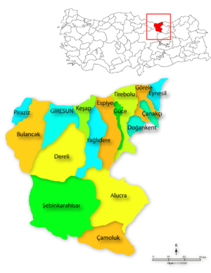
 Çanakçı Location of Çanakçı. | |
| Coordinates: 40°55′N 38°59′E / 40.917°N 38.983°ECoordinates: 40°55′N 38°59′E / 40.917°N 38.983°E | |
| Country |
|
| Region | Black Sea |
| Province | Giresun |
| Government | |
| • Mayor | Tuncay Kasım (AKP) |
| Area[1] | |
| • District | 282.18 km2 (108.95 sq mi) |
| Elevation | 372 m (1,220 ft) |
| Population (2012)[2] | |
| • Urban | 1,700 |
| • District | 6,917 |
| • District density | 25/km2 (63/sq mi) |
| Time zone | EET (UTC+2) |
| • Summer (DST) | EEST (UTC+3) |
| Postal code | 28810 |
| Area code(s) | 0454 |
| Licence plate | 28 |
| Climate | Cfb |
| Website | http://www.canakci.bel.tr/ |
Çanakçı is a town and a district of Giresun Province in the Black Sea region of Turkey.
Çanakçı is a small town of 1,848 people in a district of forest and scattered villages inland from the Black Sea coastal town of Görele.
It was founded as a village of Görele. Çanakçı became a town in 1991.
Famous "Kuşdili" festival is held in Çanakçı every July. Hundreds of people from nearby places attend this festival.
The Kemenche, which is one of the traditional Eastern Black Sea instruments, is played in Çanakçı. One of the most important folk songs is "Çanakçı'dan aşağı".
References
- ↑ "Area of regions (including lakes), km²". Regional Statistics Database. Turkish Statistical Institute. 2002. Retrieved 2013-03-05.
- ↑ "Population of province/district centers and towns/villages by districts - 2012". Address Based Population Registration System (ABPRS) Database. Turkish Statistical Institute. Retrieved 2013-02-27.
External links
This article is issued from Wikipedia - version of the 3/14/2015. The text is available under the Creative Commons Attribution/Share Alike but additional terms may apply for the media files.
