Aarau
| Aarau | ||
|---|---|---|
|
Aarau old town | ||
| ||
 Aarau | ||
|
Location of Aarau  | ||
| Coordinates: 47°24′N 8°03′E / 47.400°N 8.050°ECoordinates: 47°24′N 8°03′E / 47.400°N 8.050°E | ||
| Country | Switzerland | |
| Canton | Aargau | |
| District | Aarau | |
| Government | ||
| • Executive |
Stadtrat with 7 members | |
| • Mayor |
Stadtpräsident (list) Jolanda Urech SPS/PSS (as of February 2014) | |
| • Parliament |
Einwohnerrat with 40 members | |
| Area[1] | ||
| • Total | 12.33 km2 (4.76 sq mi) | |
| Elevation | 381 m (1,250 ft) | |
| Highest elevation (Hungerberg) | 471 m (1,545 ft) | |
| Lowest elevation (Aar) | 365 m (1,198 ft) | |
| Population (Dec 2015[2]) | ||
| • Total | 20,710 | |
| • Density | 1,700/km2 (4,400/sq mi) | |
| Demonym(s) | German: ' | |
| Postal code | 5000 | |
| SFOS number | 4001 | |
| Surrounded by | Rohr, Buchs, Suhr, Unterentfelden, Eppenberg-Wöschnau, Erlinsbach | |
| Twin towns | Neuchâtel (Switzerland), Delft (Netherlands), Reutlingen (Germany) | |
| Website |
www SFSO statistics | |
Aarau (German pronunciation: [ˈaːraʊ], locally [ˈɑːræʊ]) is the capital of the northern Swiss canton of Aargau. The town is also the capital of the district of Aarau. It is German-speaking and predominantly Protestant. Aarau is situated on the Swiss plateau, in the valley of the Aare, on the river's right bank, and at the southern foot of the Jura mountains,[3] and is west of Zürich,[4] and 65 kilometres (40 mi) northeast of Bern.[5] The municipality borders directly on the canton of Solothurn to the west. It is the second-largest town in Aargau after Wettingen. At the beginning of 2010 Rohr became a suburb of Aarau.[6]
The official language of Aarau is (the Swiss variety of Standard) German, but the main spoken language is the local variant of the Alemannic Swiss German dialect.
Geography and geology

The old city of Aarau is situated on a rocky outcrop at a narrowing of the Aare river valley, at the southern foot of the Jura mountains.[7] Newer districts of the city lie to the south and east of the outcrop, as well as higher up the mountain, and in the valley on both sides of the Aare. The neighboring municipalities are Küttigen to the north, Rohr and Buchs to the east, Suhr to the south-east, Unterentfelden to the south, and Eppenberg-Wöschnau and Erlinsbach to the west. Aarau and the nearby neighboring municipalities have grown together and now form an interconnected agglomeration. The only exception is Unterentfelden whose settlements are divided from Aarau by the extensive forests of Gönhard and Zelgli. Approximately nine-tenths of the city is south of the Aar, and one tenth is to the north. It has an area, as of 2006, of 8.9 km2 (3.4 sq mi). Of this area, 6.3% is used for agricultural purposes, while 34% is forested. Of the rest of the land, 55.2% is settled (buildings or roads) and the remainder (4.5%) is non-productive (rivers or lakes).[8] The lowest elevation, 365 meters (1,198 ft), is found at the banks of the Aar, and the highest elevation, at 471 meters (1,545 ft), is the Hungerberg on the border with Küttigen.
Climate
| Climate data for Aarau, Switzerland | |||||||||||||
|---|---|---|---|---|---|---|---|---|---|---|---|---|---|
| Month | Jan | Feb | Mar | Apr | May | Jun | Jul | Aug | Sep | Oct | Nov | Dec | Year |
| Average high °C (°F) | 2.2 (36) |
4.7 (40.5) |
9.2 (48.6) |
13.5 (56.3) |
18.2 (64.8) |
21.6 (70.9) |
24.2 (75.6) |
23.4 (74.1) |
20.0 (68) |
13.9 (57) |
7.0 (44.6) |
3.1 (37.6) |
13.4 (56.1) |
| Daily mean °C (°F) | −0.3 (31.5) |
1.2 (34.2) |
4.5 (40.1) |
8.4 (47.1) |
12.8 (55) |
16.1 (61) |
18.2 (64.8) |
17.2 (63) |
14.0 (57.2) |
9.3 (48.7) |
4.0 (39.2) |
0.7 (33.3) |
8.8 (47.8) |
| Average low °C (°F) | −2.5 (27.5) |
−1.6 (29.1) |
0.5 (32.9) |
3.6 (38.5) |
7.6 (45.7) |
10.8 (51.4) |
12.5 (54.5) |
12.0 (53.6) |
9.5 (49.1) |
6.1 (43) |
1.6 (34.9) |
−1.3 (29.7) |
4.9 (40.8) |
| Average precipitation mm (inches) | 74 (2.91) |
74 (2.91) |
70 (2.76) |
79 (3.11) |
92 (3.62) |
124 (4.88) |
107 (4.21) |
117 (4.61) |
84 (3.31) |
72 (2.83) |
87 (3.43) |
81 (3.19) |
1,060 (41.73) |
| Average precipitation days (≥ 1.0 mm) | 11.8 | 10.5 | 12.3 | 11.9 | 12.4 | 12.4 | 11.3 | 11.9 | 8.7 | 8.5 | 11.3 | 11.4 | 134.4 |
| Mean monthly sunshine hours | 29 | 62 | 106 | 135 | 167 | 186 | 222 | 189 | 153 | 86 | 40 | 26 | 1,401 |
| Source: MeteoSwiss[9] | |||||||||||||
History
Prehistory



A few artifacts from the Neolithic period were found in Aarau. Near the location of the present train station, the ruins of a settlement from the Bronze Age (about 1000 BC) have been excavated. The Roman road between Salodurum (Solothurn) and Vindonissa passed through the area, along the route now covered by the Bahnhofstrasse. In 1976 divers in the Aare found part of a seven-meter wide wooden bridge from the late Roman times.
Middle Ages

Aarau was founded around AD 1240 by the counts of Kyburg.[4] Aarau is first mentioned in 1248 as Arowe. Around 1250 it was mentioned as Arowa. However the first mention of a city sized settlement was in 1256.[10] The town was ruled from the "Rore" tower, which has been incorporated into the modern city hall.
In 1273 the counts of Kyburg died out. Agnes of Kyburg, who had no male relations, sold the family's lands to King Rudolf I von Habsburg. He granted Aarau its city rights in 1283.[5] In the 14th century the city was expanded in two stages, and a second defensive wall was constructed. A deep ditch separated the city from its "suburb;" its location is today marked by a wide street named "Graben" (meaning Ditch).
In 1415 Bern invaded lower Aargau with the help of Solothurn. Aarau capitulated after a short resistance, and was forced to swear allegiance to the new rulers.[5] In the 16th century, the rights of the lower classes were abolished. In March 1528 the citizens of Aarau allowed the introduction of Protestantism at the urging of the Bernese. A growth in population during the 16th Century led to taller buildings and denser construction methods. Early forms of industry developed at this time; however, unlike in other cities, no guilds were formed in Aarau.
On 11 August 1712, the Peace of Aarau was signed into effect. This granted each canton the right to choose their own religion thereby ending Catholicism's control.[11][12] Starting in the early 18th century, the textile industry was established in Aarau. German immigration contributed to the city's favorable conditions, in that they introduced the cotton and silk factories. These highly educated immigrants were also responsible for educational reform and the enlightened, revolutionary spirit that developed in Aarau.
1798: Capital of the Helvetic Republic
On 27 December 1797, the last Tagsatzung of the Old Swiss Confederacy was held in Aarau. Two weeks later a French envoy continued to foment the revolutionary opinions of the city. The contrast between a high level of education and a low level of political rights was particularly great in Aarau, and the city refused to send troops to defend the Bernese border. By Mid-March 1798 Aarau was occupied by French troops.
On 22 March 1798 Aarau was declared the capital of the Helvetic Republic.[7] It is therefore the first capital of a unified Switzerland. Parliament met in the city hall. On 20 September, the capital was moved to Lucerne.
Aarau as canton capital
In 1803, Napoleon ordered the fusion of the cantons of Aargau, Baden and Fricktal. Aarau was declared the capital of the new, enlarged canton of Aargau. In 1820 the city wall was torn down, with the exception of the individual towers and gates, and the defensive ditches were filled in.
The wooden bridge, dating from the Middle Ages, across the Aare was destroyed by floods three times in thirty years, and was replaced with a steel suspension bridge in 1851. This was replaced by a concrete bridge in 1952. The city was linked up to the Swiss Central Railway in 1856.
The textile industry in Aarau broke down in about 1850 because of the protectionist tariff policies of neighboring states. Other industries had developed by that time to replace it, including the production of mathematical instruments, shoes and cement. Beginning in 1900, numerous electrical enterprises developed. By the 1960s, more citizens worked in service industries or for the canton-level government than in manufacturing. During the 1980s many of the industries left Aarau completely.
In 1802 the Canton School was established; it was the first non-parochial high school in Switzerland. It developed a good reputation, and was home to Nobel Prize winners Albert Einstein, Paul Karrer, and Werner Arber, as well as several Swiss politicians and authors.
The purchase of a manuscript collection in 1803 laid the foundation for what would become the Cantonal Library, which contains a Bible annotated by Huldrych Zwingli,[13] along with the manuscripts and incunabula.[5] More newspapers developed in the city, maintaining the revolutionary atmosphere of Aarau. Beginning in 1820, Aarau has been a refuge for political refugees.
The urban educational and cultural opportunities of Aarau were extended through numerous new institutions. A Theatre and Concert Hall was constructed in 1883, which was renovated and expanded in 1995–96. The Aargau Nature Museum opened in 1922. A former cloth warehouse was converted into a small theatre in 1974, and the alternative culture center KIFF (Culture in the fodder factory) was established in a former animal fodder factory.
Origin of the name
The earliest use of the place name was in 1248 (in the form Arowe), and probably referred to the settlement in the area before the founding of the city. It comes, along with the name of the River Aare (which was called Arula, Arola, and Araris in early times), from the German Au, meaning floodplain.
Old town

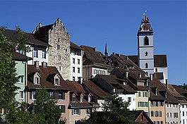
The historic old town forms an irregular square, consisting of four parts (called Stöcke). To the south lies the Laurenzenvorstadt, that is, the part of the town formerly outside the city wall. One characteristic of the city is its painted gables, for which Aarau is sometimes called the "City of beautiful Gables". The old town, Laurenzenvorstadt, government building, cantonal library, state archive and art museum are all listed as heritage sites of national significance.[14]
The buildings in the old city originate, on the whole, from building projects during the 16th century, when nearly all the Middle Age period buildings were replaced or expanded. The architectural development of the city ended in the 18th century, when the city began to expand beyond its (still existing) wall. Most of the buildings in the "suburb" date from this time.
The "Schlössli" (small Castle), Rore Tower and the upper gate tower have remained nearly unchanged since the 13th century. The "Schlössli" is the oldest building in the city. It was already founded at the time of the establishment of the city shortly after 1200; the exact date is not known. City hall was built around Rore Tower in 1515.

The upper gate tower stands beside the southern gate in the city wall, along the road to Lucerne and Bern. The jail has been housed in it since the Middle Ages. A Carillon was installed in the tower in the middle of the 20th century, the bells for which were provided by the centuries-old bell manufacturers of Aarau.
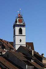
The town church was built between 1471 and 1478. During the Reformation, in 1528, its twelve altars and accompanying pictures were destroyed. The "Justice fountain" (Gerechtskeitbrunnen) was built in 1634, and is made of French limestone; it includes a statue of Lady Justice made of sandstone, hence the name. It was originally in the street in front of city hall, but was moved to its present location in front of the town church in 1905 due to increased traffic.
Economy
As of 2007, Aarau had an unemployment rate of 2.35%. As of 2005, there were 48 people employed in the primary economic sector and about 9 businesses involved in this sector. 4,181 people are employed in the secondary sector and there are 164 businesses in this sector. 20,186 people are employed in the tertiary sector, with 1,461 businesses in this sector.[8] This is a total of over 24,000 jobs, since Aarau's population is about 16,000 it draws workers from many surrounding communities. As of 2000 there were 8,050 total workers who lived in the municipality. Of these, 4,308 or about 53.5% of the residents worked outside Aarau while 17,419 people commuted into the municipality for work. There were a total of 21,161 jobs (of at least 6 hours per week) in the municipality.[15]
The largest employer in Aarau is the cantonal government, the offices of which are distributed across the entire city at numerous locations. One of the two head offices of the Aargauer Zeitung, Switzerland's fifth largest newspaper, is located in Aarau, as are the Tele M1 television channel studios, and several radio stations.
Kern & Co., founded in 1819, was an internationally known geodetic instrument manufacturer based in Aarau. However, it was taken over by Wild Leitz in 1988, and was closed in 1991.
More than half of the workers in Aarau live in the city's suburbs, or farther away in the surrounding area. This leads to a busy rush hour, and regular traffic jams. Statistically, Aarau has the most jobs per capita of any Swiss city.
The small scale of Aarau causes it to continually expand the borders of its growth. The urban center lies in the middle of the "Golden Triangle" between Zürich, Bern, and Basel, and Aarau is having increasing difficulty in maintaining the independence of its economic base from the neighboring large cities. The idea of merging Aarau with its neighboring suburbs has been recently discussed in the hope of arresting the slowly progressing losses.
Manufacture include bells, mathematical instruments, electrical goods, cotton textiles, cutlery, chemicals, shoes, and other products. Aarau is famous for the quality of their instruments, cutlery and their bells.[5][7][13]
Markets and fairs
Every Saturday morning there is a vegetable market in the Graben at the edge of the Old City. It is supplied with regional products. In the last week of September the MAG (Market of Aarauer Tradesmen) takes place there, with regional companies selling their products. The "Rüeblimärt" is held in the same place on the first Wednesday in November, which is a Carrot fair. The Aarau fair is held at the ice skating rink during the Spring.
Transport
Aarau railway station is a terminus of the S-Bahn Zürich on the line S3.
The town is also served with public transport provided by Busbetrieb Aarau AG.
Population
The population of Aarau grew continuously from 1800 until about 1960, when the city reached a peak population of 17,045, more than five times its population in 1800. However, since 1960 the population has fallen by 8%. There are three reasons for this population loss: firstly, since the completion of Telli (a large apartment complex), the city has not had any more considerable land developments. Secondly, the number of people per household has fallen; thus, the existing dwellings do not hold as many people. Thirdly, population growth was absorbed by neighboring municipalities in the regional urban area, and numerous citizens of Aarau moved into the countryside. This trend might have stopped since the turn of the 21st century. Existing industrial developments are being used for new purposes instead of standing empty.
Aarau has a population (as of 31 December 2015) of 20,710.[16] As of 2008, 19.8% of the population was made up of foreign nationals.[17] Over the last 10 years the population has grown at a rate of 1%. Most of the population (as of 2000) speaks German (84.5%), with Italian being second most common ( 3.3%) and Serbo-Croatian being third ( 2.9%).[8]
The age distribution, as of 2008, in Aarau is; 1,296 children or 8.1% of the population are between 0 and 9 years old and 1,334 teenagers or 8.4% are between 10 and 19. Of the adult population, 2,520 people or 15.8% of the population are between 20 and 29 years old. 2,518 people or 15.8% are between 30 and 39, 2,320 people or 14.6% are between 40 and 49, and 1,987 people or 12.5% are between 50 and 59. The senior population distribution is 1,588 people or 10.0% of the population are between 60 and 69 years old, 1,219 people or 7.7% are between 70 and 79, there are 942 people or 5.9% who are between 80 and 89,and there are 180 people or 1.1% who are 90 and older.[18]
As of 2000, there were 1,365 homes with 1 or 2 persons in the household, 3,845 homes with 3 or 4 persons in the household, and 2,119 homes with 5 or more persons in the household. The average number of people per household was 1.99 individuals.[19] In 2008 there were 1,594 single family homes (or 18.4% of the total) out of a total of 8,661 homes and apartments.[20]
In Aarau about 74.2% of the population (between age 25–64) have completed either non-mandatory upper secondary education or additional higher education (either university or a Fachhochschule).[8] Of the school age population (in the 2008/2009 school year), there are 861 students attending primary school, there are 280 students attending secondary school, there are 455 students attending tertiary or university level schooling, there are 35 students who are seeking a job after school in the municipality.[19]
| Population Growth[4][10] | |||||||
|---|---|---|---|---|---|---|---|
| year | population | Swiss Nationals |
% German Speaking |
% Italian Speaking |
% Romansh Speaking |
% Protestant | % Roman Catholic |
| 1558 | ca. 1,200 | ||||||
| 1764 | 1, 868 | ||||||
| 1798 | 2, 458 | ||||||
| 1850 | 4,657 | 4,299 | 0.0% | 0.0% | 0.0% | 0.0% | 0.0% |
| 1880a | 5,914 | 5,381 | 99.2% | 0.7% | 0.2% | 81.9% | 17.4% |
| 1910 | 9,593 | 7,986 | 90.6% | 2.2% | 6.7% | 71.7% | 26.6% |
| 1930 | 11,666 | 10,472 | 95.3% | 1.7% | 2.3% | 72.7% | 25.4% |
| 1950 | 14,280 | 13,373 | 93.8% | 2.2% | 3.2% | 70.4% | 27.9% |
| 1970 | 16,881 | 13,782 | 82.4% | 1.6% | 11.2% | 60.1% | 37.6% |
| 1987 | 15,750 | 75% | |||||
| 1990 | 16,481 | 13,146 | 81.7% | 1.0% | 5.3% | 49.7% | 33.0% |
| 1993 | 15,900[7] | ||||||
Sport
The football club FC Aarau play in the Stadion Brügglifeld. From 1981 until 2010 they played in the top tier of the Swiss football league system when they were relegated to the Swiss Challenge League. In the 2013/2014 they climbed back to the highest tier only to be relegated again. In the 2016/17 season they will play in the Swiss Challenge League. They won the Swiss Cup in 1985 and were three times Swiss football champions, in 1912, in 1914 and in 1993.
Sites
Heritage sites of national significance

Aarau is home to a number of sites that are listed as Swiss heritage sites of national significance. The list includes three churches; the Christian Catholic parish house, the Catholic parish house, and the Reformed City Church. There are five government buildings on the list; the Cantonal Library, which contains many pieces important to the nation's history,[21] and Art Gallery, the old Cantonal School, the Legislature, the Cantonal Administration building, and the archives. Three gardens or parks are on the list; Garten Schmidlin, Naturama Aargau and the Schlossgarten. The remaining four buildings on the list are; the former Rickenbach Factory, the Crematorium, the Haus zum Erker at Rathausgasse 10 and the Restaurant Zunftstube at Pelzgasse.[14]
Tourist Sites
The Bally Shoe company has a unique shoe museum in the city.[13] There is also the Trade Museum which contain stained glass windows from Muri Convent and paintings.[13]
Religion
From the 2000 census, 4,473 or 28.9% are Roman Catholic, while 6,738 or 43.6% belonged to the Swiss Reformed Church. Of the rest of the population, there are 51 individuals (or about 0.33% of the population) who belong to the Christian Catholic i.e. Old Catholic faith.[19]
Government
Legislative
In place of a town meeting, a town assembly (Einwohnerrat) of 50 members is elected by the citizens, and follows the policy of proportional representation. It is responsible for approving tax levels, preparing the annual account, and the business report. In addition, it can issue regulations. The term of office is four years. In the last two elections the parties had the following representation:
| Party | 2001 | 2005 |
|---|---|---|
| FDP | 13 | 12 |
| SP | 12 | 12 |
| SVP | 11 | 9 |
| CVP | 4 | 4 |
| Pro Aarau | 4 | 4 |
| Green | 2 | 4 |
| EVP | 3 | 3 |
| JETZT! | 1 | 2 |
At the district level, some elements of the government remain a direct democracy. There are optional and obligatory referendums, and the population retains the right to establish an initiative.
Executive
The executive authority is the town council (Stadtrat). The term of office is four years, and its members are elected by a plurality voting system. It leads and represents the municipality. It carries out the resolutions of the assembly, and those requested by the canton and national level governments.
The seven members (and their party) for the period 2006–2009 are:
- Dr. Marcel Guignard (FDP) (City President)
- Beat Blattner (SP) (City Vice President)
- Jolanda Urech (SP)
- Rudolf Zinniker (FDP)
- Lukas Pfisterer (FDP)
- Carlo Mettauer (CVP)
- Michael Ganz (Pro Aarau)
National elections
In the 2007 federal election the most popular party was the SP which received 27.9% of the vote. The next three most popular parties were the SVP (22.1%), the FDP (17.5%) and the Green Party (11.8%).[8]
Coat of arms
The blazon of the municipal coat of arms is Argent an Eagle displayed Sable beaked langued and membered Gules and a Chief of the last.[22]
Notable residents
- Johann Kaspar Riesbeck (1754–1786), author and actor
- Johann Rudolf Dolder (1753–1807), politician
- Sebastian Fahrländer (1768–1841), politician, physician
- Johann Heinrich Daniel Zschokke (1771–1848), writer
- Ignaz Paul Vitalis Troxler (1780–1866), physician, politician, philosopher
- Carl Feer-Herzog (1820–1880), politician
- Albert Einstein (1879–1955), scientist
- Charles Tschopp (1899–1982), writer
- Born in Aarau:
- Eugen Bircher (1882–1956), politician
- Erika Burkart (1922–2010), writer and poet
- Martha Burkhardt (1874–1956), painter
- Ferdinand Rudolph Hassler, (1770–1843), first director of the United States Coast Survey.[23]
- Maximilian Bircher-Benner
- Urs Faes, author
- Sylvia Flückiger-Bäni (born 1952), politician
- Friedrich Frey-Herosé (1801–1873), member of the Swiss Federal Council
- Hans Herzog (1819–1894), general
- Paul Hubschmid, actor
- Klaus Merz, author
- Nicolas Hunziker, Automotive Fine Artist
- Nicolas Müller, snowboarder
International relations
Twin towns – Sister cities
Aarau is twinned with:
 Neuchâtel, Switzerland
 Delft, Netherlands
 Reutlingen, Germany
See also
- Lenzburg (boasts a historical museum)
Footnotes
- ↑ Arealstatistik Standard - Gemeindedaten nach 4 Hauptbereichen
- ↑ Swiss Federal Statistical Office - STAT-TAB, online database – Ständige und nichtständige Wohnbevölkerung nach institutionellen Gliederungen, Geburtsort und Staatsangehörigkeit (German) accessed 30 August 2016
- ↑ Bridgwater & Aldrich 1968, p. 11
- 1 2 3 Hoiberg 2010, pp. 1–2
- 1 2 3 4 5 Van Valkenburg & Haefner 1997, p. 2
- ↑ Oberholzer 2013
- 1 2 3 4 Cohen 1998, p. 1
- 1 2 3 4 5 Anon 2013
- ↑ Anon 2013a
- 1 2 Lüthi 2009
- ↑ Luck 1985, p. 227
- ↑ Hall 1991, p. 134
- 1 2 3 4 Ogrizek & Rufenacht 1949, p. 43
- 1 2 Swiss Confederation 2009, p. 33
- ↑ Department of Finance and Resources 2013
- ↑ Swiss Federal Statistical Office - STAT-TAB, online database – Ständige und nichtständige Wohnbevölkerung nach institutionellen Gliederungen, Geburtsort und Staatsangehörigkeit (German) accessed 30 August 2016
- ↑ Department of Finance and Resources 2013a
- ↑ Department of Finance and Resources 2013b
- 1 2 3 Department of Finance and Resources 2013c
- ↑ Department of Finance and Resources 2013d
- ↑ Young & Stetler 1987, p. 699
- ↑ Heimer 2001
- ↑ Galgoul, Wilson & Konya 1963, p. 308
References
- Anon (2013). "Regional Portraits: Communes". Swiss Federal Statistics Office. Retrieved 15 November 2013.
- Anon (2013a). "Climate Normals Buchs/Aarau 1961–1990" (PDF). Climate Diagrams and Normals from Swiss Measuring Stations. Federal Office of Meteorology and Climatology (MeteoSwiss). Retrieved 15 November 2013.
- Bridgwater, W.; Aldrich, Beatrice, eds. (1968). "Aarau". The Columbia-Viking Desk Encyclopedia. Viking Press. ASIN B000HMLHXA.
- Cohen, Saul B., ed. (1998). "Aarau". The Columbia Gazetteer of the World. New York, NY: Columbia University Press. ISBN 0-231-11040-5.
- Department of Finance and Resources (2013). "Statistical Department of Canton Aargau – Area 11 – Transport and Communications". Retrieved 21 January 2010.
- Department of Finance and Resources (2013a). "Statistical Department of Canton Aargau – Area 01 – Population". Retrieved 20 January 2010.
- Department of Finance and Resources (2013b). "Statistical Department of Canton Aargau – Bevölkerungsdaten für den Kanton Aargau und die Gemeinden (Archiv)" [Population data for the canton of Aargau and the municipalities (archive)]. Retrieved 20 January 2010.
- Department of Finance and Resources (2013c). "Statistical Department of Canton Aargau – Aargauer Numbers 2009". Retrieved 20 January 2010.
- Department of Finance and Resources (2013d). "Statistical Department of Canton Aargau". Retrieved 20 January 2010.
- Hall, Richard T. (Jul 1991). "Switzerland – A Capsule History" (PDF). Tell. American Helvetia Philatelic Society. XVII (4): 132–136. Retrieved 29 March 2014.
- Heimer, Željko (2001). "Aarau Commune (Aargau Canton, Switzerland)". Flags of the World.com. Retrieved 15 November 2013.
- Hoiberg, Dale H., ed. (2010). "Aarau". Encyclopædia Britannica. I: A–Ak – Bayes (15th ed.). Chicago, IL: Encyclopædia Britannica, Inc. ISBN 978-1-59339-837-8.
- Luck, J. Murray (1985). History of Switzerland, The first 100,000 Years: Before the Beginnings to the Days of the Present. Palo Alto, CA: The Society for the Promotion of Science and Scholarship, Inc. ISBN 0-930664-06-X.
- Lüthi, Alfred (2009). "Aarau". Historical Dictionary of Switzerland. Retrieved 10 April 2014.
- Galgoul, Barbara Wardell; Wilson, Juanita; Konya, Rose, eds. (1963). "Hassler, Ferdinand Rudolph". Who Was Who in America, Historical Volume, 1607–1896 (Revised ed.). Chicago, IL: Marquis Who's Who. ISBN 978-0837902364.
- Oberholzer, Ernst (2013). "Amtliches Gemeindeverzeichnis der Schweiz" [Unofficial community directory of Switzerland] (PDF). Swiss Federal Statistical Office. Retrieved 15 November 2013.
- Ogrizek, Doré; Rufenacht, J. G., eds. (1949). Seitzerland. The World in Color. USA: Whittlesey House. ASIN B007T2XM5W.
- Swiss Confederation (2009). "Schweizerisches Inventar der Kulturgüter von nationaler Bedeutung" [Swiss Inventory of Cultural Property of National and Regional Significance] (PDF). Retrieved 15 November 2013.
- Van Valkenburg, Samuel; Haefner, Harold (1997). "Aarau". In Johnston, Bernard. Collier's Encyclopedia. I: A to Ameland (1st ed.). New York, NY: P.F. Collier.
- Young, Margaret Walsh; Stetler, Susan L., eds. (1987). "Switzerland". Other cities. Cities of the World. 3: Europe and the Mediterranean Middle East (3rd ed.). Detroit, MI: Gale Research Company. ISBN 0-8103-2541-1.
External links
| Wikivoyage has a travel guide for Aarau. |
- Aarau.ch
- Aarau in German, French and Italian in the online Historical Dictionary of Switzerland.
Sister projects
![]() Media related to Aarau at Wikimedia Commons
Media related to Aarau at Wikimedia Commons
 Texts on Wikisource:
- "Aarau". Encyclopædia Britannica (11th ed.). 1911.
- "Aarau". Collier's New Encyclopedia. 1921.
