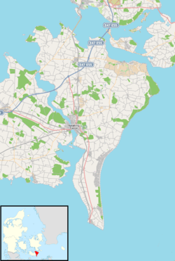
Aastrup, Falster
| Aastrup | |
|---|---|
| Village | |
|
Aastrup Church | |
 Aastrup Location on Falster | |
| Coordinates: 54°50′57″N 12°05′08″E / 54.84917°N 12.08556°E | |
| Country | Denmark |
| Region | Zealand (Sjælland) |
| Municipality | Guldborgsund |
| Time zone | CET (UTC+1) |
| • Summer (DST) | CEST (UTC+2) |
Aastrup is a little village in eastern Falster, Denmark, located 6 km (3.7 mi) southwest of Stubbekøbing.[1] Aastrup Church, built in the Romanesque style, has frescos from the 13th and 15th century.[2]
The first documented reference to the village dates from 1419 when it was called Østrup.[3]
From 1908 to 1965, the Stubbekøbing–Nykøbing railway (Stubbekøbingbanen) went through Aastrup, 4.2 km from Stubbekøbing, where there was a station with a ticket office and a siding.[4][5]
References
- ↑ Maps (Map). Google Maps.
- ↑ Kirsten Weber-Andersen, Otto Norn, Aage Roussell, Gertrud Købke Knudsen, "Tingsted Kirke", Danmarks kirker: Maribo amt, Volume 8, 1951, Nationalmuseet, pages 1345–1358. (Danish) Retrieved 14 November 2012.
- ↑ "Åstrup", Historisk Atlas. (Danish) Retrieved 6 December 2012.
- ↑ "Stubbekøbing - Nykøbing - Nysted Banen (Stubbekøbingbanen)", Jernbanen.dk. (Danish) Retrieved 6 December 2012.
- ↑ "2 - Stationer: (Stubbekøbing) - Nykøbing F.", EVP Danmark. (Danish) Retrieved 6 December 2012.
External links
- Stations on the Stubbekøbing–Nykøbing Railway with photographs of Aastrup, c. 1950
This article is issued from Wikipedia - version of the 3/20/2014. The text is available under the Creative Commons Attribution/Share Alike but additional terms may apply for the media files.
