Achada Santo António


Achada Santo António (or as Cha das Areias) is a volcanic plateau and a subdivision in the south of Praia in the island of Santiago, Cape Verde and forming one of the southernmost neighborhoods. Its area covers about 80 to 90 hectares, its length is less than a kilometer and its width ranges from 600 to 800 meters.
The highest point is about 10 meters, the lowest point is the Atlantic and the Bay of Porto Praia. Its length of is about 400 meters and 700 meters at the beach/avenue part and its width is about 400 meters from east to west. Its area is about 30 to 40 hectares.
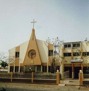
The plateau is named after the small chapel of Saint Anthony.
Bordering neighbourhoods includes Gamboa or Chã das Areias to the north, the resort area of Prainha to the east and also where much of the embassies are located, Cidadela to the west, Terra Branca to the northwest and Várzea to the north. The road linking the center of Praia and Cidade Velha, Ribeira Grande and Porto Mosquito is to the north.
History
Agriculture dominated the area up to the 1950s when the urban sprawl of Praia spread to the area; it was not fully urbanized until the 1990s. The street plan is of orthogonal form. It formed the westernmost and the southernmost of the Praia built-up area until the early 1990s.
In the 1970s, Radio Cabo Verde started construction of the headquarters of the radio station and then started its national broadcast later. In 1988, the national news agency Cabopress was established, it became Inforpress in 1998. On August 1, 1997, Cape Verde's first television station TCV (Televisão de Cabo Verde) started broadcasting and is north of the radio station building on Rua 13 de Janeiro, construction started in 1995.[1]
The football (soccer) club, Tchadense, a Badiu form of the name was founded in 1984 and was registered in October 1995. It has a small football (soccer) field, the club plays at Estádio da Várzea while the youth club plays in the field.[2] Later in 1991, Expresso das Ilhas headquarters was founded.
About Achada de Santo António
Other landmarks includes the Protestant church. It is home to the national newspaper named Expresso das Ilhas located on 21 Avenida ONU. The National Assembly is located in the middle of the neighborhood. The French school École Internationale Les Alizés. Cape Verde's national broadcasting station RTC is headquartered in the middle. Not far is the Capeverdean news agency, Inforpress located in Largo de Marconi.
Also a pedagogic instutude and a medical clinic are located in this subdivision.
Numerous streets includes Avenida de ONU (named after the United Nations). One residential street is named Cidade de Funchal (city of Funchal), named after Praia's twinning with Funchal in the Madeira Islands and another Rua Uccla named after UCCLA, the Union of Afro-Pan-American-Asiatic Lusophony Capital Cities in which Praia is a member, another one is Figueira Foz.
One of four variants of tabanka is the Achada de Santo António variant common in the neighborhood and other areas including the west of Praia.[3]
Landmarks and points of interest
- Chapel of Santo António (Saint Anthony)
- Protestant Church
- Achada Santo António football (soccer) field
- École Internationale Les Alizés, a French school
- Institude or Paedagogics
- Several ministry offices
- Technical School (Escola Técnica)
Panoramics
Panoramics includes the south of the island, the southernmost part of Praia, in the northern part, the rest of Praia except for the western part and the north of the island can be seen. In the south, it is one of the starting points where the neighboring island of Fogo, the eastern part can be seen in southern Santiago.
Transportation
Five transit lines passes through the plateau often or sometimes, the last three do not cross by the Atlantic, they include:[4]
- São Filipe – Plateau - Achada Santo António
- Ponta d’Água - Plateau - Achada Santo António
- Achada Mato – Plateau - Meio de Achada
- São Filipe – Plateau - Achada Santo António - second route
- São Filipe – Plateau - Achada Santo António - via Avenida Cidade de Lisboa
References
- ↑ "Short history of Televisão de Cabo Verde" (in Portuguese). TCV ( Televisão de Cabo Verde). Retrieved 1 April 2016.
- ↑ "History of Tchadense at a blog page at Blogspot" (in Portuguese).
- ↑ Gonçalves, C. F. (2006). Kab Verd Band.
- ↑ http://www.asemana.publ.cv/spip.php/mes_squelettes/img/spip.php?article94283&ak=1 (Portuguese)
Coordinates: 14°54′33″N 23°31′02″W / 14.9093°N 23.5171°W


