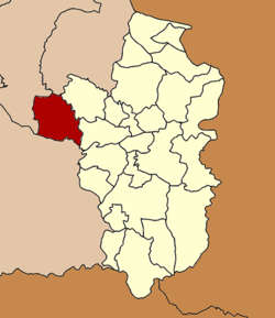
Khueang Nai District
| Khueang Nai เขื่องใน | |
|---|---|
| Amphoe | |
 Amphoe location in Ubon Ratchathani Province | |
| Coordinates: 15°23′22″N 104°33′5″E / 15.38944°N 104.55139°ECoordinates: 15°23′22″N 104°33′5″E / 15.38944°N 104.55139°E | |
| Country |
|
| Province | Ubon Ratchathani |
| Seat | Khueang Nai |
| Area | |
| • Total | 772.8 km2 (298.4 sq mi) |
| Population (2005) | |
| • Total | 109,453 |
| • Density | 141.6/km2 (367/sq mi) |
| Time zone | THA (UTC+7) |
| Postal code | 34150 |
| Geocode | 3404 |
Khueang Nai (Thai: เขื่องใน) is a district (Amphoe) in the northwestern part of Ubon Ratchathani Province, northeastern Thailand.
Geography
Neighboring districts are (from the east clockwise) Muang Sam Sip, Mueang Ubon Ratchathani of Ubon Ratchathani province, Kanthararom, Yang Chum Noi of Sisaket Province, Kho Wang, Maha Chana Chai, Kham Khuean Kaeo of Yasothon Province and Hua Taphan of Amnat Charoen Province.
History
Originally named Pachin Ubon (ปจิมอุบล, western Ubon), in 1913 the district was renamed to Trakan Phuet Phon (ตระการพืชผล).[1] In 1917, the district was renamed to Khueang Nai.[2]
Administration
The district is subdivided into 18 subdistricts (tambon), which are further subdivided into 180 villages (muban). Khueang Nai is a subdistrict municipality (thesaban tambon) which covers parts of tambon Khueang Nai. There are further 18 Tambon administrative organizations (TAO).
| No. | Name | Thai | Villages | Inh.[3] |
|---|---|---|---|---|
| 1. | Khueang Nai | เขื่องใน | 12 | 10,182 |
| 2. | Sang Tho | สร้างถ่อ | 15 | 9,538 |
| 3. | Kho Thong | ค้อทอง | 11 | 6,342 |
| 4. | Ko E | ก่อเอ้ | 12 | 7,410 |
| 5. | Hua Don | หัวดอน | 11 | 6,399 |
| 6. | Chi Thuan | ชีทวน | 11 | 6,594 |
| 7. | Tha Hai | ท่าไห | 13 | 9,049 |
| 8. | Na Kham Yai | นาคำใหญ่ | 8 | 3,933 |
| 9. | Daeng Mo | แดงหม้อ | 6 | 3,248 |
| 10. | That Noi | ธาตุน้อย | 10 | 6,294 |
| 11. | Ban Thai | บ้านไทย | 12 | 6,615 |
| 12. | Ban Kok | บ้านกอก | 6 | 3,913 |
| 13. | Klang Yai | กลางใหญ่ | 11 | 5,619 |
| 14. | Non Rang | โนนรัง | 7 | 4,449 |
| 15. | Yang Khi Nok | ยางขี้นก | 10 | 4,816 |
| 16. | Si Suk | ศรีสุข | 8 | 5,403 |
| 17. | Sahathat | สหธาตุ | 7 | 3,056 |
| 18. | Nong Lao | หนองเหล่า | 10 | 5,840 |
References
- ↑ แจ้งความกระทรวงมหาดไทย เรื่อง เปลี่ยนนามอำเภอ (PDF). Royal Gazette (in Thai). 30 (0 ง): 1536–1537. October 12, 1913.
- ↑ ประกาศกระทรวงมหาดไทย เรื่อง เปลี่ยนชื่ออำเภอ (PDF). Royal Gazette (in Thai). 34 (0 ก): 40–68. 1917-04-29.
- ↑ "Population statistics 2008". Department of Provincial Administration.
External links
- amphoe.com (Thai)