Birlapur
| Birlapur বিড়লাপুর | |
|---|---|
| Town | |
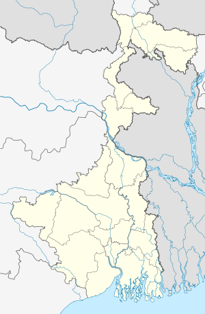 Birlapur  Birlapur Location in West Bengal, India | |
| Coordinates: 22°26′09″N 88°08′50″E / 22.4358°N 88.14729°ECoordinates: 22°26′09″N 88°08′50″E / 22.4358°N 88.14729°E | |
| Country |
|
| State | West Bengal |
| District | South 24 Parganas |
| Population (2011) | |
| • Total | 22,078 |
| Languages | |
| • Official | Bengali, English |
| Time zone | IST (UTC+5:30) |
| Vehicle registration | WB |
| Website |
s24pgs |
Birlapur is a census town in Budge Budge I CD Block under Nadakhali police station of Alipore sadar subdivision in South 24 Parganas district in the state of West Bengal, India.[1]
Demographics
As per 2011 Census of India Birlapur had a total population of 22,078, of which 11,542 (52%) were males and 10,536 (48%) were females. Population below 6 years was 3,004. The total number of literates in Birlapur was 14,829 (77.74 % of the population over 6 years).[2]
As of 2001 India census,[3] Birlapur had a population of 19,830. Males constitute 55% of the population and females 45%. Birlapur has an average literacy rate of 61%, higher than the national average of 59.5%; with male literacy of 68% and female literacy of 52%. 13% of the population is under 6 years of age.
History
Birlapur was founded by Mr. M.P.Birla. He established different factories here. Birlapur is famous for the Birla Jute Mill. There are one Calsium carbite factory, one linonium factory, one jute fibre factory and auto trim factory also. There is a co-educational high school named Birlapur Vidyalaya with both Hindi and Bengali medium. There is a permanent market also. The factory has its power house. Most of the employees stay in company provided quarters.
It is a place for many Birla employees and their children who spent most of their childhood in this serene and peaceful urban village.
In the recent years, Birlapur has seen lots of financial crisis as most of the factories are closing down, however, it is a great place to live and raise your children. Birlapur needs an eye of a new investor for its thriving and successful future, as it used to be in 90's.
References
- ↑ "Census of India". District-wise list of stautory towns. Directorate of census operations, West Bengal. Archived from the original on 2007-08-09. Retrieved 2007-09-02.
- ↑ "C.D. Block Wise Primary Census Abstract Data(PCA)". 2011 census: West Bengal – District-wise CD Blocks. Registrar General and Census Commissioner, India. Retrieved 26 April 2016.
- ↑ "Census of India 2001: Data from the 2001 Census, including cities, villages and towns (Provisional)". Census Commission of India. Archived from the original on 2004-06-16. Retrieved 2008-11-01.
Cities, towns and locations in South 24 Parganas district | |||||||||||||||||||
|---|---|---|---|---|---|---|---|---|---|---|---|---|---|---|---|---|---|---|---|
| Cities, municipal and census towns |
| ||||||||||||||||||
| Locations other than cities and towns | |||||||||||||||||||
| Related topics |
| ||||||||||||||||||
22°26′09″N 88°08′50″E / 22.4358°N 88.14729°E