Breaks Interstate Park
| Breaks Interstate Park | |
|---|---|
|
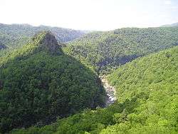
Breaks Canyon, May 2003 | |
 Location on Kentucky/Virginia border | |
| Location | Kentucky and Virginia, United States |
| Nearest city | Elkhorn City, Kentucky |
| Coordinates | 37°17′47″N 82°17′49″W / 37.29639°N 82.29694°WCoordinates: 37°17′47″N 82°17′49″W / 37.29639°N 82.29694°W |
| Area | 4,500 acres (1,800 ha) |
| Established | 1954 |
| Visitors | 286,401[1] (in 2014) |
| Governing body | Breaks Interstate Park Compact |
| http://www.breakspark.com | |
Breaks Interstate Park is a bi-state state park located partly in southeastern Kentucky and mostly in southwestern Virginia, in the Jefferson National Forest, at the northeastern terminus of Pine Mountain. Rather than their respective state park systems, it is instead administered by an interstate compact between the states of Virginia[2] and Kentucky.[3] It is one of several interstate parks in the United States, but only one of two operated jointly under a compact rather than as two separate state park units. The Virginia Department of Conservation and Recreation and the Kentucky Department of Parks are still major partner organizations, however.
The Breaks, also referred as the "Grand Canyon of the South", is the deepest gorge east of the Mississippi River,[4] through which the Russell Fork river and Clinchfield Railroad (now the CSX Transportation Kingsport Subdivision) run. It is accessed via highway 80 (Virginia 80 and Kentucky 80), between Haysi, Virginia and Elkhorn City, Kentucky, and passes through the community of Breaks, Virginia east of the park.
American frontiersman Daniel Boone is credited with being the first person of European descent to discover the Breaks, which he first saw in 1767.[5]
Geography
Breaks Interstate Park is located about 5 miles (8 km) east of Elkhorn City, Kentucky. The park covers 4,500 acres (1,800 ha). The park's main feature, Breaks Canyon, is five miles long and ranges from 830 to 1,600 feet (250 to 490 m) deep. The canyon was formed by the Russell Fork river through millions of years of erosion.[4]
Activities and amenities
- Trails: The park has trails for hiking [25 miles (40 km)], mountain biking [12 miles (19 km)], and horseback riding.[6]
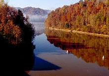
- Water-based: The park has a water park with five waterslides, a current channel, and splash pad for small children, in the summer of 2014 the park also added a regulation sized volleyball court. The park also offers fishing, paddle boating, canoeing, and hydro biking on Laurel Lake, and white-water rafting on the Russell Fork.[6]
- Rock Climbing: The Breaks offers world-class rock climbing with sandstone similar to the nearby New River Gorge.
- Accommodations: The park offers a lodge with 82 guest rooms, four cottages near Beaver Pond, five cabins overlooking Laurel Lake, and a 122-site campground and a group camping area with 16 sites.[6]
- In addition the park has a visitor center with exhibits on the area's historical and natural features, a 6,000-square-foot (560 m2) conference center with restaurant, and an amphitheater.[7]
Gallery
| Wikimedia Commons has media related to Breaks Interstate Park. |
References
- ↑ Virginia State Parks 2014 Attendance and Economic Impact Archived April 2, 2015, at the Wayback Machine. Virginia Department of Conservation and Recreation. Retrieved 2015-03-17.
- ↑ "Virginia State Park Locations". Virginia Department of Conservation and Recreation. 25 June 2013. Retrieved September 24, 2013.
- ↑ "About". Breaks Interstate Park. Kentucky Department of Parks. Retrieved September 24, 2013.
- 1 2 "Breaks Interstate Park". Virginia Tourism Corporation. June 27, 2012. Retrieved September 24, 2013.
- ↑ "Our History". Breaks Interstate Park Commission. Retrieved September 24, 2013.
- 1 2 3 "Things to do". Breaks Interstate Park. Kentucky Department of Parks. Retrieved September 23, 2013.
- ↑ "Amphitheater Music Events". Breaks Interstate Park Commission. Retrieved September 24, 2013.
External links
- Breaks Interstate Park Breaks Interstate Park Commission
- Breaks Interstate Park Kentucky Department of Parks


