Bridgewater, Virginia
| Bridgewater, Virginia | ||
|---|---|---|
| Town | ||
|
Downtown Bridgewater in winter | ||
| ||
 Location in Virginia | ||
| Coordinates: 38°23′12″N 78°58′11″W / 38.38667°N 78.96972°WCoordinates: 38°23′12″N 78°58′11″W / 38.38667°N 78.96972°W | ||
| Country | United States | |
| State | Virginia | |
| County | Rockingham | |
| Founded | 1835 | |
| Government | ||
| • Mayor | Hallie Dinkel | |
| Area | ||
| • Total | 2.4 sq mi (6.2 km2) | |
| • Land | 2.4 sq mi (6.2 km2) | |
| • Water | 0.0 sq mi (0.0 km2) | |
| Elevation | 1,178 ft (359 m) | |
| Population (2000) | ||
| • Total | 5,203 | |
| • Density | 2,169.2/sq mi (837.5/km2) | |
| Time zone | Eastern (EST) (UTC-5) | |
| • Summer (DST) | EDT (UTC-4) | |
| ZIP code | 22812 | |
| Area code(s) | 540 | |
| FIPS code | 51-09656[1] | |
| GNIS feature ID | 1492628[2] | |
| Website | Official website | |
.jpg)

Bridgewater (formerly Dinkletown and Bridgeport) is an incorporated town in Rockingham County, Virginia, United States. The population was 5,644 at the 2010 census. It is included in the Harrisonburg, Virginia Metropolitan Statistical Area. Bridgewater is also home to Bridgewater College, a private, coeducational, four-year liberal arts college founded in 1880, historically associated with the Church of the Brethren.
History
Among the first families of European descent in the area was the Dinkle family. Around 1810, John Dinkle built a sawmill and a grist mill on the North River, a tributary of the South Fork of the Shenandoah River. The tiny community was first called Dinkletown. The area was known as McGill's Ford before the Dinkles moved here.
The name was changed to Bridgeport, because it was a flatboat port at a bridge. Even after it was no longer a port, the bridge was still there, hence the final renaming as Bridgewater.[3] During the American Civil War, some troop transit and skirmishes happened nearby. The Valley Campaigns of 1864 involved the region.
In the late 19th century, the world's longest single-span wooden covered bridge stood where Main Street crosses the North River; representations of the long-gone bridge still appear in the town emblems.
In the late 19th century, Bridgewater received railroad service to connect it with Harrisonburg and beyond as the Chesapeake Western Railway was built. A railroad bridge allowed rail traffic to reach behind Round Hill and beyond—toward the general direction of Stokesville/Mt Solon. By the mid-20th century the bridge was gone except for the stone abutments. The remaining rail lines came under the control of the Norfolk and Western Railway in 1954 and Norfolk Southern in 1982. The tracks were removed in 1987.[4] The tiny two-room Bridgewater railroad depot lay vacant for years until a 1990s-2000s wave of park-building; the depot was relocated to a new park and restored.
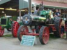
The Bridgewater Lawn Party Ground is among the town's oldest parks. Early 20th century religious sensibilities in the region frowned upon the word carnival and so the phrase lawn party was used for the annual community fairs staged there. A highlight of the "lawn party" is the long-running "steam and gas meet "—where restored steam tractors and vintage farm vehicles are exhibited and paraded. The site was officially renamed Harrison Park, though the decades-old popular name remains common.
The site of an old hydroelectric dam, the dam-keeper's building, and adjoining grounds were used as Wildwood Park. A fieldstone picnic shelter, an amusingly bouncy cable-suspension footbridge to a promontory, and a playground enlivened the site. The Flood of 1985 erased the dam-keeper's building and also "Bouncy Bridge I" ("Bouncy Bridge II" appeared later.) A deep layer of loose sand under the promontory's grass was deposited during the flood. Park restoration and acquisition of the adjoining Crawford family property let Wildwood Park expand considerably.
In the mid-1980s, an Ethan Allen factory scaled-back operations and eventually closed. The building was vacant until being bought and rented out to various tenants: a trucking company, a vintage cars restorer, a children's toy blocks distributor. Also in the mid-80s, a long-standing factory building (the Melville Footwear facility) and its landmark tall brick smokestack were demolished and on the site a distribution center for the Marshalls company was built. The new facility and also expansion at the poultry-processing plant led to increased truck-traffic on Main Street and also to a built-up "industrial" feel to the town's northern end. A riveted iron water tower loomed over the downtown block; the silver-painted structure for decades bore a graffiti tag reading Big Al. A civil defense siren the size of a small car was attached to a leg of the tower; it was tested occasionally and also served (until the late '80s when pagers and then cell phones made it obsolete) as the volunteer firefighters' call to action. (The water tower was dismantled in the late 2000s.) In the late 1980s, the town's oldest houses (log structures including the historic tollgate-keeper's building) were demolished to build a gas station and a Hardee's. Later, more historic structures were bulldozed—including a Federal Period brick house felled to build a video store. Traffic load increased, and Bridgewater went from a one-stoplight town to having five.

In the late 1990s and early 2000s, a nostalgia for the bygone Main Street charm took hold; among other changes, municipal officials installed some old-fashioned cast iron signposts. A 1990s-2000s wave of park-building and improvement added Bridgeview Park, Wynant Park, Oakdale Community Park, Warm Springs Turnpike Pocket Park, and the Cook's Creek Arboretum. Edgewater Park was remodeled: a troubled "midnight basketball" court was turned into parking and wetlands-landscaping, a water-cascade and fishpond were added, and a (flood-resistant) river-overlook platform was installed. The landscaping changes and tireless bird feeding by a small number of local enthusiasts has made the site a waterfowl haven. Sandy Bottom Park had been an overgrown scrubland surrounding a sewage system structure and road works garage—buried in a foot of sandy sediment in the Flood of 1985; improvements included removing flood-mounded driftwood and installing a nine-hole community golf course with a fine view of the Bridgewater Air Park (FAA: VBW / ICAO: KVBW) runway approach.
The abundance of parks (leaflet) along with the old grid of old and fairly wide side streets have made Bridgewater a pedestrian-friendly town visited by leisure-walking enthusiasts from the surrounding countryside (where country roads are narrow and cars drive fast).
Circa 2005, the Bridgewater College campus (prominent because Dinkle Avenue—the town's link to nearby Interstate 81—cuts across the northern end of its quad) erected large curved brick decorative walls which serve as the de facto gateway to the town from the east. In the late 2000s, decorative traffic calming features including curb extensions (prettified with mulch and flower bulbs) were added to busy Dinkle Avenue.
The Bridgewater Historic District was listed on the National Register of Historic Places in 1984.[5] Though no known notable figures were born in Bridgewater, there were a few passing associations: PGA golfer David Branshaw attended college there, artist Mia LaBerge briefly kept a studio there, and General James Robinson Risner spent his last years in the town. Also, during the Civil War, 2 October 1864 cavalry skirmishes in Bridgewater (and nearby Mount Crawford) brought George Armstrong Custer through town.
Geography
According to the United States Census Bureau, the town has a total area of 2.4 square miles (6.2 km²), all of it land. Most of the town is located within a bend of the North River. Floods have wrecked the town occasionally. The northern areas are partly shielded from flooding with an Army Corps of Engineers dam. The wooded monadnock called Round Hill (elevation approx. 1750 feet) dominates the town's western skyline. Two nearby ridges are locally nicknamed "The Bluff" and "Snob Knob"—the latter having the town's first modern upscale housing built along its top.
Demographics
| Historical population | |||
|---|---|---|---|
| Census | Pop. | %± | |
| 1880 | 390 | — | |
| 1900 | 384 | — | |
| 1910 | 859 | 123.7% | |
| 1920 | 914 | 6.4% | |
| 1930 | 951 | 4.0% | |
| 1940 | 993 | 4.4% | |
| 1950 | 1,537 | 54.8% | |
| 1960 | 1,815 | 18.1% | |
| 1970 | 2,828 | 55.8% | |
| 1980 | 3,289 | 16.3% | |
| 1990 | 3,918 | 19.1% | |
| 2000 | 5,203 | 32.8% | |
| 2010 | 5,644 | 8.5% | |
| Est. 2015 | 5,889 | [6] | 4.3% |
As of the census[1] of 2000, 5,203 people, 1,788 households, and 1,201 families resided in the town. The population density was 2,169.2 people per square mile (837.0/km²). There were 1,850 housing units at an average density of 771.3 per square mile (297.6/km²). The racial makeup of the town was 95.18% White, 2.48% African American, 0.12% Native American, 0.42% Asian, 0.94% from other races, and 0.86% from two or more races. Hispanic or Latino of any race were 3.08% of the population.
Of 1,788 households, 29.3% had children under the age of 18 living with them, 55.4% were married couples living together, 9.5% had a female householder with no husband present, and 32.8% were not families. About 29.2% of all households were made up of individuals and 14.9% had someone living alone who was 65 years of age or older. The average household size was 2.31 and the average family size was 2.85.
In the town, the population was distributed as 18.9% under the age of 18, 21.9% from 18 to 24, 22.9% from 25 to 44, 17.6% from 45 to 64, and 18.8% who were 65 years of age or older. The median age was 34 years. For every 100 females, there were 81.8 males. For every 100 females age 18 and over, there were 77.0 males.
The median income for a household in the town was $41,038, and for a family was $49,777. Males had a median income of $35,579 versus $25,255 for females. The per capita income for the town was $18,215. About 3.4% of families and 5.3% of the population were below the poverty line, including 5.3% of those under age 18 and 0.8% of those age 65 or over.
See also
| Wikimedia Commons has media related to Bridgewater, Virginia. |
References
- 1 2 "American FactFinder". United States Census Bureau. Archived from the original on 2013-09-11. Retrieved 2008-01-31.
- ↑ "US Board on Geographic Names". United States Geological Survey. 2007-10-25. Retrieved 2008-01-31.
- ↑ "Rockingham Co towns page 6". Retrieved 24 November 2014.
- ↑ "Chesapeake Western History Page". Retrieved 24 November 2014.
- ↑ National Park Service (2010-07-09). "National Register Information System". National Register of Historic Places. National Park Service.
- ↑ "Annual Estimates of the Resident Population for Incorporated Places: April 1, 2010 to July 1, 2015". Retrieved July 2, 2016.
- ↑ "Census of Population and Housing". Census.gov. Archived from the original on May 11, 2015. Retrieved June 4, 2015.
External links
Municipalities and communities of Rockingham County, Virginia, United States | ||
|---|---|---|
| Towns |  | |
| CDPs | ||
| Unincorporated communities |
| |
| Footnotes | ‡This populated place also has portions in an adjacent county or counties | |