Chriesman, Texas
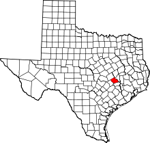
Chriesman (/ˈkrɪsmən/ KRISS-mən) is an unincorporated community in Burleson County, Texas, United States. Although it is unincorporated, it has a post office, with the ZIP code of 77838.[1]
History
The community was named in honor of Horatio Chriesman (1797–1878), a surveyor and early settler from Virginia who moved to Texas as a member of the Old Three Hundred.[2]
The community was the home of Perk Williams, fiddle player with Capitol Records artist Jimmy Heap and the Melody Masters, known for the Billboard Top Ten hit song "Release Me." Williams is celebrated at the annual "Perk Fest" at the Chriesman Community Center, located across the railroad tracks from the original downtown near the original Cotton Gin site, long since razed. An interesting structure that has been on 2 art tours is the "Bottle House", a quirky, eclectic cottage built out of thousands of wine bottles on the old Dunaway store site on FM 1363 near the Community Center. Although on private property, it is easily visible and a fun photo stop from across the fence.
Chriesman is now a virtual ghost town with only 1 original commercial building still standing: the old Post Office. It was originally an old school building and was long ago moved to its present site and the upstairs was the Justice of the Peace court. Later the 2nd story was removed and the Post Office was moved from inside the Speckman-Matejosky General Store next door. Next door on the other side was the Chriesman State Bank that closed in 1929, still solvent. This building burned not long after it closed. The old Methodist Church is still standing and holds regular services. The Presbyterian Church was next door, but was razed in the 1960s. The John and Elsie (Baumann) Speckman country Victorian home is also still standing a few blocks from where his store was located (razed in 1974).
References
- ↑ Zip Code Lookup Archived June 15, 2011, at the Wayback Machine.
- ↑ "CHRIESMAN, HORATIO," Handbook of Texas Online (http://www.tshaonline.org/handbook/online/articles/fch35), accessed June 15, 2014. Uploaded on June 12, 2010. Published by the Texas State Historical Association.
External links
Coordinates: 30°35′58″N 96°46′15″W / 30.59944°N 96.77083°W
