Clarin, Bohol
| Clarin | ||
|---|---|---|
| Municipality | ||
|
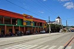
Clarin – market and church (new 2016) | ||
| ||
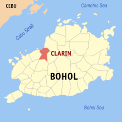 Map of Bohol with Clarin highlighted | ||
.svg.png) Clarin Location within the Philippines | ||
| Coordinates: 9°58′N 124°01′E / 9.97°N 124.02°ECoordinates: 9°58′N 124°01′E / 9.97°N 124.02°E | ||
| Country | Philippines | |
| Region | Central Visayas (Region VII) | |
| Province | Bohol | |
| District | 2nd district of Bohol | |
| Organized | 31 January 1919 | |
| Barangay | 24 (see § Barangays) | |
| Government [1] | ||
| • Type | Sangguniang Bayan | |
| • Mayor | Allen Piezas (LP) | |
| • Vice mayor | Velden Aparicio | |
| • Town Council |
Members
| |
| • Representative | Erico Aristotle Aumentado | |
| Area[2] | ||
| • Total | 52.12 km2 (20.12 sq mi) | |
| Population (2015 census)[3] | ||
| • Total | 20,301 | |
| • Density | 390/km2 (1,000/sq mi) | |
| • Voter (2016)[4] | 13,743 | |
| Time zone | PST (UTC+8) | |
| ZIP code | 6330 | |
| IDD : area code | +63 (0)38 | |
| Income class | 5th class | |
| PSGC | 071214000 | |
| Website |
www | |

Clarin is a 5th municipal income class municipality in the province of Bohol, Philippines,[2] located 61 km (38 mi) from Tagbilaran. According to the 2015 census, it has a population of 20,301.[3] In the 2016 election, it had 13,743 registered voters.[4]
Geography
2013 Bohol earthquake
Clarin was severely affected by the 2013 Bohol earthquake that damaged 1358 homes, of which 221 were totally destroyed, as well as the Catholic church.[5]
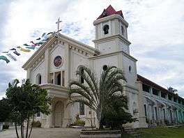 Roman Catholic Church before earthquake
 Roman Catholic Church after earthquake
Barangays
Clarin comprises 24 barangays:
| PSGC | Barangay | Population | ±% p.a. | ||
|---|---|---|---|---|---|
| 2015[3] | 2010[6] | ||||
| 071214001 | Bacani | 5.8% | 1,185 | 1,208 | −0.37% |
| 071214002 | Bogtongbod | 7.0% | 1,428 | 1,377 | +0.69% |
| 071214003 | Bonbon | 7.0% | 1,427 | 1,487 | −0.78% |
| 071214004 | Bontud | 2.4% | 497 | 456 | +1.65% |
| 071214005 | Buacao | 3.2% | 644 | 797 | −3.98% |
| 071214006 | Buangan | 4.1% | 824 | 796 | +0.66% |
| 071214007 | Cabog | 4.1% | 829 | 764 | +1.57% |
| 071214008 | Caboy | 2.8% | 569 | 571 | −0.07% |
| 071214009 | Caluwasan | 1.3% | 255 | 222 | +2.67% |
| 071214010 | Candajec | 5.2% | 1,061 | 932 | +2.50% |
| 071214011 | Cantoyoc | 1.7% | 346 | 343 | +0.17% |
| 071214012 | Comaang | 2.5% | 498 | 471 | +1.07% |
| 071214013 | Danahao | 3.4% | 693 | 856 | −3.94% |
| 071214014 | Katipunan | 1.5% | 301 | 340 | −2.29% |
| 071214015 | Lajog | 6.2% | 1,262 | 1,381 | −1.70% |
| 071214016 | Mataub | 3.1% | 632 | 700 | −1.93% |
| 071214017 | Nahawan | 10.8% | 2,202 | 2,208 | −0.05% |
| 071214018 | Poblacion Centro | 6.3% | 1,285 | 1,234 | +0.77% |
| 071214019 | Poblacion Norte | 4.1% | 831 | 838 | −0.16% |
| 071214020 | Poblacion Sur | 6.1% | 1,246 | 1,159 | +1.39% |
| 071214021 | Tangaran | 3.8% | 776 | 850 | −1.72% |
| 071214022 | Tontunan | 2.9% | 593 | 559 | +1.13% |
| 071214023 | Tubod | 2.4% | 484 | 402 | +3.60% |
| 071214024 | Villaflor | 2.1% | 423 | 345 | +3.96% |
| Total | 20,301 | 20,296 | 0.00% | ||
Demographics
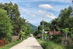
Side street in Clarin
| Population census of Clarin | |||||||||||||||||||||||||
|---|---|---|---|---|---|---|---|---|---|---|---|---|---|---|---|---|---|---|---|---|---|---|---|---|---|
|
| ||||||||||||||||||||||||
| Source: Philippine Statistics Office[3][6][7] | |||||||||||||||||||||||||
In the 2016 election, it had 13,743 registered voters, meaning that 68% of the population are aged 18 and over.[4]
Education
Elementary and primary schools
-
- Bacani Elementary School
- Bogtongbod Elementary School
- Bonbon Elementary School
- Buacao Primary School
- Buangan Elementary School
- Buntod Primary School
- Caboy Elementary School
- Clarin Central Elementary School
- Danahaw Elementary School
- Lajog Elementary School
- Nahawan Elementary School
- Tontunan Elementary School
Secondary schools
-
- Clarin National School of Fisheries
- Nahawan High School
Tertiary schools
References
- ↑ "Municipality". Quezon City, Philippines: Department of the Interior and Local Government. Retrieved 31 May 2013.
- 1 2 "Municipal: Clarin, Bohol". PSGC Interactive. Quezon City, Philippines: Philippine Statistics Authority. Retrieved 8 January 2016.
- 1 2 3 4 "Region VII (CENTRAL VISAYAS)". Census of Population (2015): Total Population by Province, City, Municipality and Barangay (Report). PSA. Retrieved 20 June 2016.
- 1 2 3 "2016 National and Local Elections Statistics". Commission on Elections. 2016.
- ↑ "SitRep No. 35 re Effects of Magnitude 7.2 Sagbayan, Bohol Earthquake" (PDF). National Disaster Risk Reduction and Management Council. November 3, 2013. Retrieved December 17, 2013.
- 1 2 "Region VII (CENTRAL VISAYAS)". Census of Population and Housing (2010): Total Population by Province, City, Municipality and Barangay (Report). NSO. Retrieved 29 June 2016.
- ↑ "Region VII (CENTRAL VISAYAS)". Census of Population (1995, 2000 and 2007): Total Population by Province, City and Municipality (Report). NSO. Archived from the original on 24 June 2011.
External links
| Wikimedia Commons has media related to Clarin, Bohol. |
 |
Cebu Strait | Inabanga | | |
| Tubigon | |
Sagbayan | ||
| ||||
| | ||||
| Catigbian |
This article is issued from Wikipedia - version of the 8/6/2016. The text is available under the Creative Commons Attribution/Share Alike but additional terms may apply for the media files.
