Cloverdale, Mississippi
| Cloverdale, Mississippi | |
|---|---|
| Census-designated place | |
| Cloverdale | |
 Cloverdale | |
| Coordinates: 31°29′39″N 91°25′4″W / 31.49417°N 91.41778°WCoordinates: 31°29′39″N 91°25′4″W / 31.49417°N 91.41778°W | |
| Country | United States |
| State | Mississippi |
| County | Adams |
| Area | |
| • Total | 1.1 sq mi (2.9 km2) |
| • Land | 1.1 sq mi (2.9 km2) |
| • Water | 0 sq mi (0 km2) |
| Elevation | 190 ft (60 m) |
| Population (2010) | |
| • Total | 645 |
| • Density | 567/sq mi (218.9/km2) |
| Time zone | Central (CST) (UTC-6) |
| • Summer (DST) | CDT (UTC-5) |
| GNIS feature ID | 668617[1] |
Cloverdale is a census-designated place (CDP) in Adams County, Mississippi, United States, located to the south of the city of Natchez. As of the 2010 census, it had a population of 645.[2]
The community is located 5 miles (8 km) south of downtown Natchez on Cloverdale Road, on high ground overlooking the Mississippi River floodplain. According to the U.S. Census Bureau, it has an area of 1.1 square miles (2.9 km2), all land.[2]
References
- ↑ "Cloverdale". Geographic Names Information System. United States Geological Survey.
- 1 2 "Geographic Identifiers: 2010 Demographic Profile Data (G001): Cloverdale CDP, Mississippi". U.S. Census Bureau, American Factfinder. Retrieved June 18, 2013.
Municipalities and communities of Adams County, Mississippi, United States | ||
|---|---|---|
| Cities | 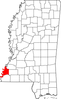 | |
| CDPs | ||
| Other unincorporated communities | ||
| Ghost towns | ||
This article is issued from Wikipedia - version of the 8/13/2014. The text is available under the Creative Commons Attribution/Share Alike but additional terms may apply for the media files.