Cooks, Michigan
| Cooks, Michigan | |
|---|---|
| Unincorporated community | |
 Cooks, Michigan | |
| Coordinates: 45°55′04″N 86°28′35″W / 45.91778°N 86.47639°WCoordinates: 45°55′04″N 86°28′35″W / 45.91778°N 86.47639°W[1] | |
| Country | United States |
| State | Michigan |
| County | Schoolcraft |
| Township | Inwood |
| Elevation[1] | 699 ft (213 m) |
| Time zone | Eastern (EST) (UTC-5) |
| • Summer (DST) | EDT (UTC-4) |
| ZIP code | 49817 |
| Area code(s) | 906 |
| GNIS feature ID | 1619567[1] |
Cooks is an unincorporated community in Schoolcraft County, Michigan, United States. Cooks is located in Inwood Township along the Canadian National Railway north of U.S. Route 2, 11.5 miles (18.5 km) west-southwest of Manistique.[2] Cooks has a post office with ZIP code 49817.[3]
History
Cooks was founded in 1883 when John C. Cook built a sawmill at the community. The community was originally named Cook's Mills before being shortened to Cooks. A post office opened in the community on June 28, 1888; Norman McDonald was the first postmaster. The community had a station on the Minneapolis, St. Paul and Sault Ste. Marie Railroad under the name Cooks Mill.[4]
References
- 1 2 3 U.S. Geological Survey Geographic Names Information System: Cooks, Michigan
- ↑ Schoolcraft County (pdf) (Map). Michigan Department of Technology, Management and Budget. 2010. Retrieved 2010-12-25.
- ↑ ZIP Code Lookup, United States Post Office
- ↑ Romig, Walter (1986) [1973]. Michigan Place Names. Detroit, Michigan: Wayne State University Press. ISBN 0-8143-1838-X.
Municipalities and communities of Schoolcraft County, Michigan, United States | ||
|---|---|---|
| City | 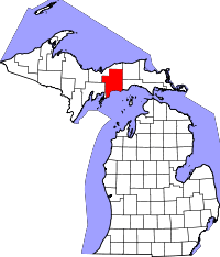 | |
| Townships | ||
| Unincorporated communities | ||
This article is issued from Wikipedia - version of the 11/3/2014. The text is available under the Creative Commons Attribution/Share Alike but additional terms may apply for the media files.