CountrySide, Virginia

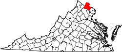
CountrySide is a census-designated place in Loudoun County, Virginia. The population as of the 2010 United States Census was 10,072.[1] CountrySide is located about 30 miles (48 km) northwest of Washington and is bounded by the Potomac River to the north, and by Route 7 (Leesburg Pike) to the south. Located in eastern Loudoun County, it is about 9 miles (14 km) from Washington Dulles International Airport.
History
The CountrySide subdivision was conceived in the middle 1970s when a tract of 1,000 acres (4 km²) of open farmland was subdivided in preparation for a planned housing development. Construction on homes began in 1981 and continued through 1991.
Today, CountrySide covers about 3.75 square miles (9.7 km2) and consists of 2,539 homes, which includes 1,269 single-family homes, 1,168 town homes, and 102 Condominium units. Its population in 1990 was 8,349 residents, and the average household income is $118,500. Homes in CountrySide have a 20165 ZIP code.
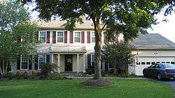
The majority of the homes in CountrySide were built by the homebuilder Pulte Homes, and are of the colonial architectural style. Most of the single-family homes have two stories and a basement. CountrySide is governed by the CountrySide Proprietary, the community's homeowners association.
Recreation
The community contains an extensive network of paved paths that wind through the wooded neighborhoods. It also contains three swimming pools. A network of smaller hiking trails branch off the main trail and are used for hiking, mountain biking, nature-watching and jogging. Some of the trails were developed by Eagle Scouts, others gradually by hikers; still others predate CountrySide itself. Planned integration with the Potomac Heritage Trail is in dispute despite the PHT's federally granted easement.
Schools
CountrySide students attend CountrySide Elementary School, Algonkian Elementary School, River Bend Middle School, and Potomac Falls High School.
References
- ↑ Virginia Trend Report 2: State and Complete Places (Sub-state 2010 Census Data). Missouri Census Data Center. Accessed 2011-03-08.
External links
- Aerial view of CountrySide on Windows Live Local
- CountrySide on Google Maps
- CountrySide Elementary School
- Algonkian Elementary School
- River Bend Middle School
- Potomac Falls High School
- CountrySide Proprietary web site
- The History of CountrySide
Coordinates: 39°02′27″N 77°24′49″W / 39.04083°N 77.41361°W
