Solms
| Solms | ||
|---|---|---|
| ||
 Solms | ||
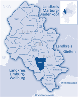
Location of Solms within Lahn-Dill-Kreis district  | ||
| Coordinates: 50°32′23″N 08°24′26″E / 50.53972°N 8.40722°ECoordinates: 50°32′23″N 08°24′26″E / 50.53972°N 8.40722°E | ||
| Country | Germany | |
| State | Hesse | |
| Admin. region | Gießen | |
| District | Lahn-Dill-Kreis | |
| Government | ||
| • Mayor | Frank Inderthal (SPD) | |
| Area | ||
| • Total | 34.05 km2 (13.15 sq mi) | |
| Population (2015-12-31)[1] | ||
| • Total | 13,456 | |
| • Density | 400/km2 (1,000/sq mi) | |
| Time zone | CET/CEST (UTC+1/+2) | |
| Postal codes | 35606 | |
| Dialling codes | 06442 | |
| Vehicle registration | LDK | |
| Website | www.solms.de | |
| County of Solms | ||||||||||||
| Grafschaft Solms | ||||||||||||
| State of the Holy Roman Empire | ||||||||||||
| ||||||||||||
| Capital | Solms | |||||||||||
| Government | Principality | |||||||||||
| Historical era | Middle Ages | |||||||||||
| • | Established | 1129 | ||||||||||
| • | Partitioned to S-Braunfels and S-Burg-Solms |
1258 1258 | ||||||||||
| ||||||||||||
| Full style: Count of Solms, Lord of Münzenberg, Wildenfels and Sonnenwalde | ||||||||||||
| County of Solms: Town of Solms | ||||||||||
| Grafschaft Solms-Burg-Solms | ||||||||||
| State of the Holy Roman Empire | ||||||||||
| ||||||||||
| Capital | Solms | |||||||||
| Government | Principality | |||||||||
| Historical era | Middle Ages | |||||||||
| • | Partitioned from Solms | 1258 | ||||||||
| • | Annexed to S-Braunfels | 1415 | ||||||||
| ||||||||||
Solms is a town west of Wetzlar in the Lahn-Dill-Kreis, Hessen, Germany.
In the constituent community of Burgsolms once stood the ancestral castle of the Counts and Princes of Solms.
Geography
Location
Solms lies right in the Lahn valley and is nestled between the foothills of both the Taunus and Westerwald at heights from 140 to 400 m above sea level. It is about 7 km west of Wetzlar and 30 km northeast of Limburg an der Lahn.
Neighbouring communities
Solms borders in the north on the community of Ehringshausen and the town of Aßlar, in the east on the town of Wetzlar, in the south on the community of Schöffengrund, and in the west on the town of Leun (all in the Lahn-Dill-Kreis).
Constituent communities
The town consists of the following centres:
- Albshausen
- Burgsolms
- Niederbiel
- Oberbiel
- Oberndorf
History

Solms had its first documentary mention in 788 in a donation document from the Lorsch Monastery. The villages that nowadays form the town of Solms belonged for centuries to the County of Solms, an independent state within the Holy Roman Empire, elevated to a county in 1223, until it was dissolved in 1806. The still existing lines of the House of Solms are the princely branches of Solms-Braunfels with their seat in Braunfels, Solms-Hohensolms-Lich with their seat in Lich and Solms-Baruth, furthermore the Counts of Solms-Laubach with their seat in Laubach, Solms-Rödelheim-Assenheim with their seat in Assenheim, Solms-Sonnewalde and Solms-Wildenfels. The Burgsolms castle at Solms, ancestral seat of the family since around 1100, was destroyed in 1384 by a coalition of nearby towns under the leadership of Wetzlar, forcing count John to move to Greifenstein castle.
After a short while being part of the Duchy of Nassau, Solms passed to Prussia in 1815.
As part of Hesse's municipal reforms, the communities of Albshausen and Oberbiel voluntarily merged on 1 July 1971 to form Bielhausen, while Burgsolms and Oberndorf did the same to form Solms. By state law, these two new communities were amalgamated with Niederbiel on 1 January 1977 to make the new greater community of Solms, which in 1978 was granted town rights.
A new residential area has been being built on the western edge of Oberbiel since the 1990s.
Politics
Town council
The municipal elections in 2011 yielded the following results:[2]
| Party | Seats |
|---|---|
| Freie Wählergruppe (FWG) | 23.4 |
| Social Democratic Party (SPD) | 40.3 |
| Christian Democratic Union (CDU) | 23.0 |
| Free Democratic Party (FDP) | 2.6 |
| Greens | 10.7 |
Note: FWG is a citizens' coalition.
Town of Solms Youth Council
Since 2002 there has been a Town of Solms Youth Council serving as the town's official board representing youth's interests and needs. It is elected every two years by children and youths who either live in the town or go to the comprehensive school.
Partnerships
The town of Solms maintains partnerships with the following places:
Economy and infrastructure
Oberbiel is home to two commercial-industrial areas. A shipping company has set up shop at the newer one, while the older one, on an island in the river Lahn, was established in the early 20th century. It was originally home to a brad factory, a wireworks and a ball bearing factory.
Sightseeing
- Kloster Altenberg (Altenberg Monastery) of the blessed Gertrud von Altenberg, Saint Elisabeth's daughter (Oberbiel)
- "Grube Fortuna" Visitors' Mine (Oberbiel)
- Jewish Cemetery (Burgsolms)
- Burgsolms Youth Centre (Stadionstraße 26), as well as youth areas in all constituent communities
References
- ↑ "Bevölkerung der hessischen Gemeinden". Hessisches Statistisches Landesamt (in German). August 2016.
- ↑ GRÜNE SOLMS http://www.gruene-solms.de/archiv/kommunalwahl-2011/. Missing or empty
|title=(help)
