Deux-Nèthes

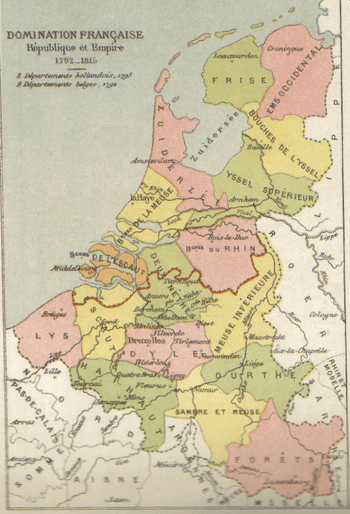
Deux-Nèthes (Dutch: Twee Nethen) was a department of the First French Empire in present-day Belgium and the Netherlands. It was named after two branches of the river Nete. The southern part of its territory corresponds more or less with the present-day Belgian province of Antwerp.
It was formed in 1795, when the Southern Netherlands were annexed by France. Its territory was the northern part of the former duchy of Brabant. After the annexation of the Kingdom of Holland in 1810, the department was expanded with the western half of the present-day Dutch province North Brabant (arrondissement Breda). Its capital was Antwerp.
The department was subdivided into the following arrondissements and cantons (situation in 1812):[1]
- Antwerp, cantons: Antwerp (4 cantons), Brecht, Ekeren, Kontich, Wilrijk and Zandhoven.
- Breda, cantons: Bergen op Zoom, Breda, Ginneken, Oosterhout, Oudenbosch, Roosendaal and Zevenbergen.
- Mechelen, cantons: Duffel, Heist-op-den-Berg, Lier, Mechelen (2 cantons) and Puurs.
- Turnhout, cantons: Arendonk, Herentals, Hoogstraten, Mol, Turnhout and Westerlo.
Its population in 1812 was 367,184, and its area was 415,380 hectares.[1]
After Napoleon was defeated in 1814, the department became part of the United Kingdom of the Netherlands as the province of Antwerp.
References
- 1 2 Almanach Impérial an bissextil MDCCCXII, p. 442-443, accessed in Gallica 26 July 2013 (French)
Coordinates: 51°13′N 4°24′E / 51.217°N 4.400°E
