Edgar, Montana
| Edgar, Montana | |
|---|---|
| Census-designated place | |
 Edgar  Edgar | |
| Coordinates: 45°27′55″N 108°51′13″W / 45.46528°N 108.85361°WCoordinates: 45°27′55″N 108°51′13″W / 45.46528°N 108.85361°W | |
| Country | United States |
| State | Montana |
| County | Carbon |
| Area[1] | |
| • Total | 0.68 sq mi (1.77 km2) |
| • Land | 0.68 sq mi (1.77 km2) |
| • Water | 0 sq mi (0 km2) |
| Elevation | 3,474 ft (1,059 m) |
| Population (2010)[2] | |
| • Total | 114 |
| • Density | 167/sq mi (64.4/km2) |
| Time zone | Mountain (MST) (UTC-7) |
| • Summer (DST) | MDT (UTC-6) |
| ZIP code | 59026 |
| Area code(s) | 406 |
| GNIS feature ID | 771137[3] |
Edgar is a census-designated place and unincorporated community in Carbon County, Montana, United States. As of the 2010 census it had a population of 114.[2] Although it is unincorporated, Edgar has a post office with a ZIP code of 59026.[4]
Edgar lies east of the intersection of U.S. Route 310 and Elwell Street. Edgar is south of Rockvale and northeast of Fromberg. Edgar is a small, agricultural community with a number of silos and elevators. It is also home to a bar & grill restaurant and some other services.
References
- ↑ "US Gazetteer files: 2010, 2000, and 1990". United States Census Bureau. 2011-02-12. Retrieved 2011-04-23.
- 1 2 "Geographic Identifiers: 2010 Demographic Profile Data (G001): Edgar CDP, Montana". U.S. Census Bureau, American Factfinder. Retrieved October 8, 2014.
- ↑ U.S. Geological Survey Geographic Names Information System: Edgar, Montana
- ↑ Zip Code Lookup
Municipalities and communities of Carbon County, Montana, United States | ||
|---|---|---|
| City | 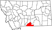 | |
| Towns | ||
| CDPs | ||
| Other unincorporated communities | ||
This article is issued from Wikipedia - version of the 8/8/2016. The text is available under the Creative Commons Attribution/Share Alike but additional terms may apply for the media files.