Falkirk (council area)
| Falkirk Fawkirk An Eaglais Bhreac | ||
|---|---|---|
| ||
 | ||
| Admin HQ | Falkirk | |
| Government | ||
| • Body | Falkirk Council | |
| • Control | Lab + Con + Ind (council NOC) | |
| • MPs | ||
| • MSPs | ||
| Area | ||
| • Total | 115 sq mi (297 km2) | |
| Area rank | Ranked 22nd | |
| Population (2010 est.) | ||
| • Total | 156,000 | |
| • Rank | Ranked 11th | |
| • Density | 1,340/sq mi (516/km2) | |
| ONS code | 00QQ | |
| ISO 3166 code | GB-FAL | |
| Website |
www | |
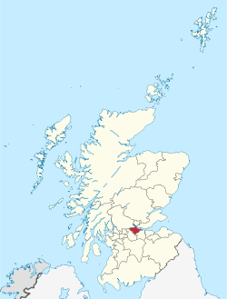
Falkirk (Scots: Fawkirk, Scottish Gaelic: An Eaglais Bhreac) is one of 32 unitary authority council areas of Scotland. It was formed on 1 April 1996 from the exact boundaries of Falkirk District Council by way of the Local Government etc. (Scotland) Act 1994. Prior to 1975 the majority of the council area was part of the county of Stirlingshire, and a small part, namely Bo'ness and Blackness, was part of the former county of West Lothian.
The council area borders with North Lanarkshire, Stirling and West Lothian, and, across the Firth of Forth to the northeast, Clackmannanshire and Fife.
From 2003 to 2007 the Council was led by an SNP/Independent coalition, but after the 2007 elections a Labour/Ind coalition of 16 councillors equalled the SNP/ Tory/ Independent 16, so a pack of cards was cut. Labour's card was higher than the SNP's. To form a stable administration Labour then formed a coalition with the 4 members of the Conservative and Independent Partnership. This Labour/Conservative/Independent coalition hold 18 seats compared to the 13 SNP and 1 non-aligned Independent. The leader of the administration is Councillor Craig Martin.
Towns and villages
- Airth
- Allandale
- Avonbridge
- Bainsford
- Banknock
- Blackness
- Bo'ness
- Bonnybridge
- Brightons
- California
- Camelon
- Carron
- Carronshore
- Denny
- Dennyloanhead
- Dunipace
- Dunmore
- Falkirk (town)
- Grangemouth
- Haggs
- Hallglen/Glen Village
- Larbert
- Laurieston
- Letham
- Limerigg
- Longcroft
- Maddiston
- Polmont
- Redding
- Reddingmuirhead
- Rumford
- Shieldhill
- Skinflats
- Slamannan
- Standburn
- Stenhousemuir
- Tamfourhill
- Torwood
- Wallacestone
- Westquarter
- Whitecross
- Woodlands
Council political composition
Following the elections on 3 May 2012, the composition of Falkirk Council is as follows:
| Party | Councillors | |
| Labour | 14 | |
| Scottish National Party | 13 | |
| Independent | 3 | |
| Conservative | 2 |
As such, the Council is controlled by a Labour/Conservative/Independent coalition.
Electoral wards
For the purposes of elections to Falkirk Council, the Falkirk area is divided geographically into a number of wards which then elect either three or four councillors each by the Single Transferable Vote system. The electoral system of local councils in Scotland is governed by the Local Governance (Scotland) Act 2004, an Act of the Scottish Parliament which first introduced proportional representation to councils. These electoral wards are as follows:
- Ward 1 - Bo'ness and Blackness (3 councillors)
- Ward 2 - Grangemouth (4 councillors)
- Ward 3 - Denny and Banknock (4 councillors)
- Ward 4 - Carse, Kinnaird and Tryst (4 councillors)
- Ward 5 - Bonnybridge and Larbert (3 councillors)
- Ward 6 - Falkirk North (4 councillors)
- Ward 7 - Falkirk South (4 councillors)
- Ward 8 - Lower Braes (3 councillors)
- Ward 9 - Upper Braes (3 councillors)
Education
See also: Category:Education in Falkirk (council area), Category:Schools in Falkirk (council area)
Falkirk has 8 secondary schools, 50 primary schools and 5 schools for children with additional support needs. Further education is provided by the Falkirk campus of Forth Valley College.
External links
- Falkirk Council Website
- Falkirk (council area) at DMOZ
- Falkirk Community Trust Website
- Royal National Mod, Falkirk 10-18 Oct 2008
- Things to do around Falkirk


