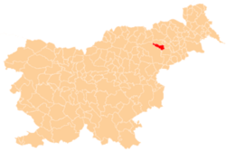
Fram, Rače–Fram
| Fram | |
|---|---|
|
Postcard of Fram | |
 Fram Location in Slovenia | |
| Coordinates: 46°27′22.72″N 15°37′45.98″E / 46.4563111°N 15.6294389°ECoordinates: 46°27′22.72″N 15°37′45.98″E / 46.4563111°N 15.6294389°E | |
| Country |
|
| Traditional region | Styria |
| Statistical region | Drava |
| Municipality | Rače–Fram |
| Area | |
| • Total | 5.47 km2 (2.11 sq mi) |
| Elevation | 321 m (1,053 ft) |
| Population (2002) | |
| • Total | 791 |
| [1] | |
Fram (pronounced [ˈfɾaːm]) is a village in the Municipality of Rače–Fram in northeastern Slovenia. It lies in the eastern foothills of the Pohorje range south of Maribor. The area is part of the traditional region of Styria. The municipality is now included in the Drava Statistical Region.[2]
Name
The village was first attested in written sources in 1335 as Vraunhaym (and as Frawnhain in 1397, Fraunhain in 1402, and Frauenhaim in 1461). The Slovene name is a contraction of *Fraham, derived from Frauenheim, the name of the noble family that owned the castle there.[3]
Mass grave
Fram is the site of a mass grave associated with the Second World War. The Fram Mass Grave (Slovene: Grobišče Fram) is located in a wooded hilly area about 600 m northwest of the village. The grave contains the remains of a small group of local civilians.[4]
Church
The parish church in the settlement is dedicated to Saint Anne and belongs to the Roman Catholic Archdiocese of Maribor. It was built in 1875 in a Neo-Romanesque style on the site of a chapel belonging to a 13th-century castle that stood to the west of the settlement. The castle was destroyed in a fire in the late 18th century and only ruins are visible today.[5]
References
- ↑ Statistical Office of the Republic of Slovenia
- ↑ Rače–Fram municipal site
- ↑ Snoj, Marko. 2009. Etimološki slovar slovenskih zemljepisnih imen. Ljubljana: Modrijan and Založba ZRC, p. 135.
- ↑ Fram Mass Grave on Geopedia (Slovene)
- ↑ Slovenian Ministry of Culture register of national heritage reference numbers ešd 2969 & 24790

