Franklin, Michigan
| Franklin | |
|---|---|
| Village | |
| Village of Franklin | |
 | |
| Motto: "Experience It"[1] | |
 | |
| Coordinates: 42°31′12″N 83°18′14″W / 42.52000°N 83.30389°WCoordinates: 42°31′12″N 83°18′14″W / 42.52000°N 83.30389°W | |
| Country | United States |
| State | Michigan |
| County | Oakland |
| Area[2] | |
| • Total | 2.66 sq mi (6.89 km2) |
| • Land | 2.66 sq mi (6.89 km2) |
| • Water | 0 sq mi (0 km2) |
| Elevation | 833 ft (254 m) |
| Population (2010)[3] | |
| • Total | 3,150 |
| • Estimate (2012[4]) | 3,184 |
| • Density | 1,184.2/sq mi (457.2/km2) |
| Time zone | Eastern (EST) (UTC-5) |
| • Summer (DST) | EDT (UTC-4) |
| ZIP code | 48025 |
| Area code(s) | 248 |
| FIPS code | 26-30340[5] |
| GNIS feature ID | 0626409[6] |
| Website | Historic Franklin Village, Michigan |
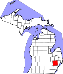
Franklin is a village in Southfield Township, Oakland County in the U.S. state of Michigan. The population was 3,150 at the 2010 census.[7] The community is known for large, estate-style homes situated on ravines, as well as its vintage downtown and a nearby cider mill.
History
The community was founded in 1825 by Elijah Bullock and other settlers, and was named Franklin in 1831. The village is named after Benjamin Franklin.[8] By 1830, a business district was formed. The collection of essentially original condition structures in the village is quite unusual in suburban Detroit. The village was incorporated in 1953.[9]
Historical markers
A historical marker was erected in 1960 which reads: "FRANKLIN VILLAGE Founded in 1824-1825, Franklin received its present name in 1828. First postmaster was Dr. Ebenezer Raynale, state legislator and physician. The William Huston store, opened in 1830, was the forerunner of a business center that later included the famous Broughton Wagon Shop, the Van Every Mills, now "Ye Olde Cider Mill," several taverns, two distilleries, and two churches. The village also was a station on the Underground Railroad. Franklin still has the appearance and atmosphere of an early Michigan village.
Another marker stands in front of Franklin Village School: "Franklin Village School Michigan's Territorial Council passed a law in 1827 requiring every township with fifty or more inhabitants to establish a school. Thus the following year, the first school in Southfield Township was erected in Franklin Village. Sophie Gotie taught twenty-nine students in a log schoolhouse located near the still extant house of early settler Daniel Broughton. Franklin village built a new school in 1845 at the foot of School Hill on property deeded by Winthrop Worthings. On this site in 1869 a third school was constructed on land given by wealthy postmaster A.A. Rust. After that building burned in 1922, the village erected the present school on this same location. The Franklin School District No. 3, Southfield Township, joined the Birmingham Public Schools in 1945." This building closed as a public school in 1979; in 1988, members of Metro Detroit's Muslim community bought the building and turned it into Huda School and Montessori, a K-8 Islamic parochial school; on Saturdays the building houses the related Dar-al-Huda Islamic Saturday school.
In 2006, the Muslim community raised $3.6 million to fund a renovation and expansion project of the school. In the summer of 2007, the Monahan Construction Company renovated the school. In September 2007, $1 million were raised in order to continue the second phase of the project which should be completed in the summer of 2008.
Geography
According to the United States Census Bureau, the village has a total area of 2.66 square miles (6.89 km2), all land.[2]
Demographics
| Historical population | |||
|---|---|---|---|
| Census | Pop. | %± | |
| 1880 | 151 | — | |
| 1960 | 2,262 | — | |
| 1970 | 3,311 | 46.4% | |
| 1980 | 2,864 | −13.5% | |
| 1990 | 2,626 | −8.3% | |
| 2000 | 2,937 | 11.8% | |
| 2010 | 3,150 | 7.3% | |
| Est. 2015 | 3,237 | [10] | 2.8% |
2010 census
As of the census[3] of 2010, there were 3,150 people, 1,118 households, and 903 families residing in the village. The population density was 1,184.2 inhabitants per square mile (457.2/km2). There were 1,177 housing units at an average density of 442.5 per square mile (170.9/km2). The racial makeup of the village was 86.2% White, 6.6% African American, 0.1% Native American, 4.8% Asian, 0.1% Pacific Islander, 0.5% from other races, and 1.7% from two or more races. Hispanic or Latino of any race were 1.3% of the population.
There were 1,118 households of which 39.2% had children under the age of 18 living with them, 74.1% were married couples living together, 4.3% had a female householder with no husband present, 2.4% had a male householder with no wife present, and 19.2% were non-families. 15.7% of all households were made up of individuals and 8% had someone living alone who was 65 years of age or older. The average household size was 2.82 and the average family size was 3.17.
The median age in the village was 45.4 years. 28.4% of residents were under the age of 18; 4.7% were between the ages of 18 and 24; 16.5% were from 25 to 44; 34.4% were from 45 to 64; and 16.2% were 65 years of age or older. The gender makeup of the village was 50.5% male and 49.5% female.
2000 census
As of the census[5] of 2000, there were 2,937 people, 1,073 households, and 866 families residing in the village. The population density was 1,105.5 per square mile (426.3/km²). There were 1,118 housing units at an average density of 420.8 per square mile (162.3/km²). The racial makeup of the village was 89.79% White, 5.07% African American, 0.10% Native American, 3.58% Asian, 0.34% from other races, and 1.12% from two or more races. Hispanic or Latino of any race were 0.85% of the population.
There were 1,073 households out of which 38.2% had children under the age of 18 living with them, 75.3% were married couples living together, 3.7% had a female householder with no husband present, and 19.2% were non-families. 15.0% of all households were made up of individuals and 7.0% had someone living alone who was 65 years of age or older. The average household size was 2.73 and the average family size was 3.06.
In the village the population was spread out with 28.3% under the age of 18, 2.9% from 18 to 24, 25.6% from 25 to 44, 29.5% from 45 to 64, and 13.8% who were 65 years of age or older. The median age was 42 years. For every 100 females there were 105.8 males. For every 100 females age 18 and over, there were 99.3 males.
The median income for a household in the village was $124,014, and the median income for a family was $139,339. Males had a median income of $100,000 versus $61,500 for females. The per capita income for the village was $71,033. About 0.5% of families and 1.0% of the population were below the poverty line, including 0.4% of those under age 18 and 1.0% of those age 65 or over.
Arts and culture
Points of interest
Franklin is known for the Franklin Cider Mill, which actually lies just north of Franklin's borders, in neighboring Bloomfield Township, although it does have a Franklin mailing address. The Franklin Cider Mill has been around since 1837, the year that Michigan became a state.[12]
Franklin's current firehouse was built in 1959. The village only employs one firefighter and a chief; the rest of the force is volunteer. The station is located on the site of the old village community hall, which ironically burned down in 1958.
Franklin was designated as Michigan's first historic district on November 11, 1969.
Franklin is home to the Radio For One Studios and "The Detroit Cast", a popular podcast featuring Mike Clark & Mike Wolters, both formerly of the Drew & Mike Morning Show on WRIF FM radio in Detroit.
Notable people
- Dan Gilbert, chairman and founder of Quicken Loans, and owner of the Cleveland Cavaliers
- Max Fisher Businessman
References
- ↑ "Historic Franklin Village, Michigan". Historic Franklin Village, Michigan. Retrieved August 25, 2012.
- 1 2 "US Gazetteer files 2010". United States Census Bureau. Retrieved 2012-11-25.
- 1 2 "American FactFinder". United States Census Bureau. Retrieved 2012-11-25.
- ↑ "Population Estimates". United States Census Bureau. Retrieved 2013-06-03.
- 1 2 "American FactFinder". United States Census Bureau. Retrieved 2008-01-31.
- ↑ U.S. Geological Survey Geographic Names Information System: Franklin, Michigan
- ↑ "Race, Hispanic or Latino, Age, and Housing Occupancy: 2010 Census Redistricting Data (Public Law 94-171) Summary File (QT-PL), Franklin village, Michigan". U.S. Census Bureau, American FactFinder 2. Retrieved August 19, 2011.
- ↑ "Profile for Franklin, Michigan, MI". ePodunk. Retrieved August 24, 2012.
- ↑ http://www.franklin.mi.us/AboutFranklin/History.asp
- ↑ "Annual Estimates of the Resident Population for Incorporated Places: April 1, 2010 to July 1, 2015". Retrieved July 2, 2016.
- ↑ "Census of Population and Housing". Census.gov. Retrieved June 4, 2015.
- ↑ "Franklin Cider Mill". Localstew.com. Retrieved July 13, 2012.
External links
| Wikivoyage has a travel guide for Franklin (Michigan). |
| Wikimedia Commons has media related to Franklin, Michigan. |
- Village of Franklin
- http://www.mcgi.state.mi.us/hso/advancematch.asp?ctype=any&cname=Franklin&cnty=Oakland
- http://www.michmarkers.com/detail.asp?txtID=L0011
- http://www.michmarkers.com/detail.asp?txtID=L0584

