Greenwood, Georgia
| Greenwood, Georgia Greenwood Community | |
|---|---|
| Unincorporated community | |
| Country | United States |
| State | Georgia |
| County | Mitchell |
| Elevation | 151 ft (46 m) |
| Time zone | Eastern (EST) (UTC-5) |
| • Summer (DST) | EDT (UTC-4) |
| ZIP code | 31730 |
| Area code(s) | 229 |
Greenwood is an Unincorporated community located in Mitchell County, Georgia, United States.[1]
Geography
Greenwood's latitude is at 31.198 and its longitude is at -84.34. Its elevation rests at 151 feet. Greenwood appears on the Branchville U.S. Geological Survey Map.[1]
Churches
The Greenwood Free Will Baptist Church sits in the area as well as the Anitoch Baptist Church.[1]
Demographics
As of 2011 Greenwood consists mostly of rural farming families.[1]
Civil
Greenwood supports two former schoolhouses. One is now Fran's Frames and Gallery. It was known as Greenwood school. It rests on Ga Hwy 97. On Greenwood Road there sits a small abandoned home next to the Greenwood Free Will Baptist Church. This is all that is left of a small one-room schoolhouse. The last classes were held in the late 1940s. It has since been divided up into rooms for a home. As of 2011 it sits empty.[1]
Location
Greenwood sits on the intersection of Ga Highway 97 and Greenwood Road. Fox Run Road, Kurbo Lane, Pipeline Road, Sassafras Tea Road, Richards Lane, and Flats Road also rest in the area.[1]
External links
Municipalities and communities of Mitchell County, Georgia, United States | ||
|---|---|---|
| Cities | 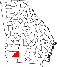 | |
| Town | ||
| Unincorporated communities | ||
| Footnotes | ‡This populated place also has portions in an adjacent county or counties | |