Halar
| Halar | |
|---|---|
| Historical region | |
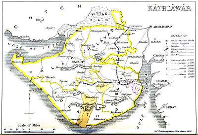 1855 map of Kathiawar with its four prant regions: Halar, Jhalawar, Sorath and Gohelwad | |
| Coordinates: 22°47′N 70°05′E / 22.783°N 70.083°ECoordinates: 22°47′N 70°05′E / 22.783°N 70.083°E | |
| Country | India |
| State | Gujarat |
| Languages | |
| • Official | Gujarati |
| Time zone | IST (UTC+5:30) |
| Vehicle registration | GJ |
| Website |
gujaratindia |
|
| |
Halar is a historical region of western India, located by the Gulf of Kutch coast on the northwestern area of Nawanagar, now Jamnagar, in Gujarat State,[1] on Saurashtra pensinsula, roughly corresponding to the present Jamnagar District and Rajkot District.
In 1901 it had an area of 19,365 km² and a population of 764,992 inhabitants.
History
The name is derived from Jam Sri Halaji Jadeja who is supposed to be the 9th-generation grandfather of Jam Sri Rawalji Lakhaji Jadeja (who is the founder of the region and the first king to reign in the region); Halar was first established with this name by Jam Shri Rawalji Lakhaji, a Jadeja Rajput, in 1540.[2]
During the British Raj Halar region was the western of the four prants or historical districts of Kathiawar, belonging to the Bombay Presidency, the others being Gohelwar (southeast), Jhalavad (north) and Sorath (southwest).
Princely States
| Princely state |
|---|
| Individual residencies |
| Agencies |
|
| Lists |
|
At that time the region included numerous princely states belonging to the Kathiawar Agency, mostly ruled by Rajputs.[3]
Its salute states were :
- First Class states :
- Second Class states :
- Wankaner (Vankaner), title Maharana Raj Sahib, Hereditary salute of 11-guns
- Dhrol, title Thakore Sahib, Hereditary salute of 9-guns
- Rajkot State, title Thakore Sahib, Hereditary salute of 9-guns
Its major non-salute states (mostly minor, usually several village) included :
- Fourth Class states : Kotda Sangani, Malia State, Virpur State
- Fifth Class states : Gadhka, Gavridad, Jalia Devani, Kotharia, Mengni, Pal State
- Sixth Class states : Bhadva, Rajpara State, Shahpur State,
- Seventh Class states : Khirasra, Lodhika State, Vadali.
Other non-salute state, granted no class, were :
- multiple villages, yet mostly minor except the first : Drafa State, Amrapur State, Kanpar Ishwaria, Mulila Deri, Satodad Vavdi, Sisang Chandli,
- single village, petty states : Bhalgam Baldhoi, Kansiali, Kotda Nayani, Virvao.
Bibliography
See also
References
- ↑ List of places in Jamnagar
- ↑ "Jadeja History - Jadeja Rajputs". Retrieved 12 November 2016.
- ↑ "Imperial Gazetteer2 of India, Volume 13, page 9 -- Imperial Gazetteer of India -- Digital South Asia Library". Retrieved 12 November 2016.