Jhalawar prant
- See Jhalawar for namesakes
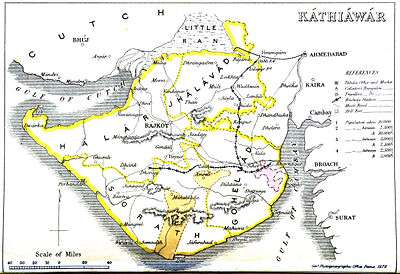
Jhalawar was the northernmost of the four prants (traditional regions) into which the many feudal units (mostly petty princely states) of Kathiawar on Saurashtra pensinsula in present Gujarat (western India) were divided, the others being Halar (west), Gohelwar (southeast) and Sorath (south).
Princely States
| Princely state |
|---|
| Individual residencies |
| Agencies |
|
| Lists |
|
Its salute states were :
- First Class : Dhrangadhra(-Halvad), title Maharaja Raj Sahib, Hereditary salute of 13-guns
- Second Class :
- Limbdi State, title Thakore Sahib, Hereditary salute of 9-guns
- Wadhwan State, title Maharana, Hereditary salute of 9-guns
Its main non-salute states included :
- Third Class : Chuda State, Lakthar State, Sayla State
- Fourth Class : Bajana State, Muli State, Patdi State
- Fifth Class : Vanod State
- Sixth Class : Anandpur State, Bhoika State, Chotila State, Dasada State, Rai-Sankli State, Rakpur State, Sanosra State, Vadod State
Other petty states, often a single village : Ankevalia,·Bamanbore, Bhadvana, Bhalala, Bhalgamda, Bharejda, Bhathan, Bhimora, Chachana, Chhalala, Chobari, Darod State,·Devlia, Dudhrej, Gedi State,·Gundiali, Jakhan State,·Jamar State,·Jhampodad, Jhinjhuvada, Kamalpur State,·Kantharia, Karmad, Karol State, Kesria, Khambhlav, Khandia, Kherali, Laliyad, Matra Timba, Mevasa, Munjpur, Palali State, Paliyad, Rajpur (Jathiawar), Ramparda, Sahuka, Samla, Sejakpur, Sudamda-Dhandalpur, Talsana, Tavi State, Untdi, Vana State, Vanala, Vithalgadh.
