Hoppaw, California
Coordinates: 41°31′27″N 124°01′48″W / 41.52417°N 124.03000°W
| Hoppaw | |
|---|---|
| Unincorporated community | |
 Hoppaw  Hoppaw Location in California | |
| Coordinates: 41°31′27″N 124°01′48″W / 41.52417°N 124.03000°W | |
| Country | United States |
| State | California |
| County | Del Norte County |
| Elevation[1] | 36 ft (11 m) |
Hoppaw is an unincorporated community in Del Norte County, California. It is located on Hoppaw Creek 3 miles (4.8 km) east-southeast of the mouth of the Klamath River,[2] at an elevation of 36 feet (11 m). It appears in the Requa U.S. Geological Survey Map.[3]
References
- ↑ U.S. Geological Survey Geographic Names Information System: Hoppaw, California
- ↑ Durham, David L. (1998). California's Geographic Names: A Gazetteer of Historic and Modern Names of the State. Clovis, Calif.: Word Dancer Press. p. 79. ISBN 1-884995-14-4.
- ↑ http://california.hometownlocator.com/ca/del-norte/hoppaw.cfm
Municipalities and communities of Del Norte County, California, United States | ||
|---|---|---|
| City | 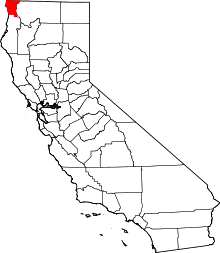 | |
| CDPs | ||
| Unincorporated communities | ||
| Indian reservations | ||
| Ghost towns |
| |
This article is issued from Wikipedia - version of the 7/5/2016. The text is available under the Creative Commons Attribution/Share Alike but additional terms may apply for the media files.