Hulme Crescents
| Hulme Crescents The Crescents | |
|---|---|
| Location | Manchester, England |
| Status | Adult-only from 1974, abandoned in 1984 by Council; Demolished 1991-94 |
| Constructed | 1972 |
| Demolished | 1994 |
| Governing Body | Manchester Corporation |
| Nico, Alain Delon, Mark Kermode | |
Hulme Crescents (known locally as just The Crescents) was a large housing development situated in the Hulme district of Manchester, England. The scheme was the largest public housing development in Europe, encompassing 3,284 deck-access homes and capacity for over 13,000 people.[1] It gained notoriety as one of the worst public housing schemes in British history and was marred by serious construction and design errors.[2] The problems were so bad the large housing scheme was short-lived and demolition on The Crescents began in 1991 - just 19 years after it was constructed in 1972.
Opening in 1972, the housing scheme was deemed to be unsuitable for families within two years due to design flaws. By 1984 the Crescents had been abandoned by Manchester City Council and stopped taking rents. The Crescents soon became a creative yet dystopian enclave of the city attracting crime as well as bohemian subcultures.
Flaws in the construction process, inadequate heating, pest infestation and unsafe design were among some of the problems occupants faced. The Crescents were described by the Architects Journal as "Europe's worst housing stock... hideous system-built deck-access block which gave Hulme its unsavoury reputation."[2] The Hulme Crescents had implications for new housing in Manchester and signalled the death knell for the 'Streets in the sky' idea that had been proposed throughout the 1960s and 1970s in the United Kingdom. The Crescents were demolished in 1994.
History
Proposal
In 1945, the Manchester Corporation published the long-term development plan. The development plan described the existing housing stock in Hulme as "Endless rows of grimy houses: no gardens, no parks, no community buildings, no hope.”[3] Manchester Corporation historically refrained from the high-rise residential tower block schemes that were eminent in other British cities such as Salford. By the 1960s a need for high-density housing had become apparent and Hulme with vacant land and housing stock perceived to be outdated was an ideal area for new housing.[4]
Nikolaus Pevsner wrote in 1969 during the housing development wrote: "the redevelopment area of Manchester, many say of England, and some of Europe. At the time of writing whole blocks lie waste, streets are blocked and new streets are made”.[1] The centrepiece of the new housing development would be the Hulme Crescents. The Crescents were designed by Hugh Wilson and Lewis Womersley - the latter was in charge of the delivery of Park Hill flats in Sheffield in the 1960s and the much-maligned Manchester Arndale retail development in the 1970s.
The housing scheme consisted of four south-facing u-shaped blocks housing flats. Each crescent was named after a distinguished architect - Adam, Nash, Barry and Kent - a decision which appeared seriously misjudged after the design failings of the Crescents surfaced. Wormersley said: "We feel that the analogy we have made with Georgian London and Bath is entirely valid. By the use of similar shapes and proportions, large-scale building groups and open spaces, and, above all, by skilful landscaping and extensive tree planning, it is our endeavour to achieve at Hulme a solution to the problems of twentieth-century living which would be the equivalent in quality that reached the requirements of eighteenth-century Bloomsbury and Bath.[2]
Failures
Two years after opening, Manchester City Council deemed The Crescents unsuitable for families and the housing scheme became adult-only. The decks had intended to be 'streets in the sky' where neighbours would see one another and children could play unsupervised.
Serious design flaws such as thick concrete balconies prevented residents from seeing one another. Worst of all, the balconies had a horizontal aperture which allowed curious children to climb onto the balcony ledge. Children climbed the balcony ledge by putting a foot in the aperture and lifting themselves onto the ledge. In 1974 this flaw came to a head when a five-year-old child died after falling from a balcony.[5] After the incident, a petition was launched and was signed by 643 residents who wished to be rehoused.[2] Manchester City Council agreed to re-house families from The Crescents and the flats were offered to students and all-adult households.

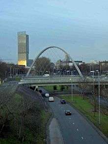
The new Mancunian Way flyover and Princess Parkway road left residents feeling isolated and "cut off" from the rest of the city.[2] The feeling persisted for decades and the Hulme Arch Bridge, built in 1997, aimed to re-establish this link to the city. Police did not patrol the upper decks despite the intention of 'Streets in the Sky' and quick responses to incidents was often complicated by the scale of the estate, which totalled over a quarter of a mile of passageways.[1] Responses to emergencies were also complicated by faulty lifts which had been described as "usually filthy" even when in service.[2]
The Crescents were not heated by radiators - but by advanced underfloor heating which was in an early stage of development during the 1970s. The architects proposed underfloor heating in the proposal stages in the late 1960s and The Crescents were completed by 1972. However the architects did not envisage the 1973 oil crisis and consequently many tenants could not afford the heating costs.[6]
Pest infestation was a problem from the outset due to serious failures in the construction and design process. The subsoil was not cleansed from pest infestation before construction of the Crescents. Cockroaches were prevalent in the undamp-proofed slum houses due to the high water and moisture availability.[7] The Crescents were district heated with long ducts linking flats together. Cockroaches and mice thrived on the warmth and ducts provided a constant source of food in waste areas. The use of asbestos in construction compounded the issue and meant that treating ducts with pesticide to remove the cockroaches was practically impossible due to the dangers of removing asbestos.[8]
The long list of failures gave the Crescents national notoriety. In 1975, just three years after opening, a survey was conducted which found 96.3% of residents wanted to leave the Crescents and be re-housed elsewhere. In 1978, the Granada Television investigative programme World in Action questioned the suitability of Hulme Crescent.[9] The Guardian described the development as "a morass in which design faults and tenants revulsion at their environment have combined to produce a staggering number of maintenance demands and angry howls of neglect".[2]
In 1980 economist Milton Friedman visited the Crescents in the fourth episode of his documentary series Free to Choose. The Crescents' residents were used as an example for his critique of the welfare state.
Abandonment
By 1984, the Crescents had become so undesired by prospective residents that Manchester City Council, which lacked sufficient funds to demolish the housing scheme, stopped charging rents entirely from tenants. However the council did still provide electricity to the building to those who needed it. The Crescents became an eclectic place for various subculture groups such as bohemians, criminals and squatters. Unwanted by the council, occupants resorted to altering The Crescents themselves. The Kitchen was an illegal nightclub which was created from three knocked-through flats and was described as a "much wilder alternative" to the nearby Haçienda club. Creative residents proceeded to put their own stamp on the building and covered the dreary grey concrete surfaces in graffiti.[10]
The Guardian critic Owen Hatherley argued that the sense of dereliction made The Crescents a breeding ground for creativity. "All the things bemoaned as deleterious to family life . . . the complexity of the blocks, the noise and sense of height, the lack of a feeling of 'ownership' in the communal areas" turned out to be "perfect" for a different sort of tenant, Manchester's young bohemians, who relished the estate's air of decaying modernism. By the early 80s, it had an art house cinema, club nights run by the soon-to-be-famous Factory Records, and even a "Hulme look" of intense youths in baggy secondhand suits. Hatherley juxtaposes the difference between the Manchester of the 1980s and 2010s: "the very fact that [many] spaces were unused . . . led to a sense of possibility absent from the sewn-up, high-rent city of today".[11]
Demolition
In 1991, the government provided Manchester with £31 million to revive housing stock. It was decided that a blank canvas approach was required and the entire Hulme Crescents was demolished from 1992 to 1994.
Post-demolition
Hulme has subsequently undergone a £400 million redevelopment programme with input from residents, most of whom advocated a return to traditional forms of terraced and semi-detached housing. Nevertheless, some former residents formed a housing co-operative, Homes for Change, whose new building purposely replicated the Crescents' medium-rise construction and communal walkways.
See also
Bibliography
- Hartwell, Clare (2001). Pevsner Architectural Guides: Manchester. Penguin.
- Parkinson-Bailey, John (2000). Manchester: An Architectural History. Manchester University Press.
- R. Burridge (2011). Unhealthy Housing: Research, remedies and reform. Taylor & Francis. ISBN 0415511712.
References
- 1 2 3 Hartwell. p. 327. Missing or empty
|title=(help) - 1 2 3 4 5 6 7 Parkinson-Bailey. p. 195. Missing or empty
|title=(help) - ↑ "The Hulme Crescents". Manchester.net. Retrieved 2012-11-27.
- ↑ "The legacy of Brutalist vitality". culturewars.org. Retrieved 2012-11-27.
- ↑ "Lessons from Hulme" (PDF). Joseph Rowntree Foundation. Retrieved 2012-11-27.
- ↑ "Hulme - History". Retrieved 2012-11-27.
- ↑ Burridge. p. 204. Missing or empty
|title=(help) - ↑ Burridge. p. 205. Missing or empty
|title=(help) - ↑ "World in Action: There's No Place Like Hulme". British Film Institute. Retrieved 2012-11-28.
- ↑ "The People's Republic of Hulme". BBC Radio Four. Retrieved 2012-11-28.
- ↑ "A Guide to the New Ruins of Great Britain by Owen Hatherley – review". The Guardian. 23 October 2010. Retrieved 2012-11-28.
Coordinates: 53°27′49″N 2°15′15″W / 53.4636°N 2.2542°W


