Hydro, Oklahoma
| Hydro, Oklahoma | |
|---|---|
| Town | |
|
Location of Hydro, Oklahoma | |
| Coordinates: 35°32′53″N 98°34′47″W / 35.5479858°N 98.5796842°WCoordinates: 35°32′53″N 98°34′47″W / 35.5479858°N 98.5796842°W | |
| Country | United States |
| State | Oklahoma |
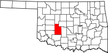
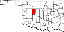
| Counties | Caddo, Blaine |
| Area | |
| • Total | 0.67 sq mi (1.74 km2) |
| • Land | 0.67 sq mi (1.74 km2) |
| • Water | 0.0 sq mi (0.0 km2) |
| Elevation | 1,555 ft (474 m) |
| Population (2010)[1] | |
| • Total | 969 |
| • Density | 1,400/sq mi (560/km2) |
| Time zone | Central (CST) (UTC-6) |
| • Summer (DST) | CDT (UTC-5) |
| ZIP code | 73048 |
| Area code(s) | 405 |
| FIPS code | 40-36700[2] |
| GNIS feature ID | 1094039[3] |
Hydro is a town in Caddo and Blaine counties in the U.S. state of Oklahoma. As of the 2010 census, the town population was 969.[1]
History
The town was founded on August 6, 1901. Built near the Choctaw, Oklahoma and Gulf Railroad, the settlement was originally called "Caddo", but when the post office was established in September 1901, the name was changed to "Hydro" in reference to the town's plentiful well water.[4]
Geography
Hydro is located near the northwestern corner of Caddo County at 35°32′56″N 98°34′40″W / 35.54889°N 98.57778°W (35.548882, -98.577762),[5] at an elevation of 1,557 feet (475 m). A small part of the town extends north into Blaine County.
The town is located 0.5 miles (0.80 km) north of Interstate 40, with access from Exit 88. I-40 leads west 7 miles (11 km) to Weatherford and east 61 miles (98 km) to downtown Oklahoma City.
According to the United States Census Bureau, Hydro has a total area of 0.66 square miles (1.7 km2), all land.[6]
Demographics
| Historical population | |||
|---|---|---|---|
| Census | Pop. | %± | |
| 1910 | 562 | — | |
| 1920 | 686 | 22.1% | |
| 1930 | 948 | 38.2% | |
| 1940 | 759 | −19.9% | |
| 1950 | 714 | −5.9% | |
| 1960 | 697 | −2.4% | |
| 1970 | 805 | 15.5% | |
| 1980 | 938 | 16.5% | |
| 1990 | 977 | 4.2% | |
| 2000 | 1,060 | 8.5% | |
| 2010 | 969 | −8.6% | |
| Est. 2015 | 960 | [7] | −0.9% |
| U.S. Decennial Census | |||
As of the census[2] of 2000, there were 1,060 people, 413 households, and 280 families residing in the town. The population density was 1,752.4 people per square mile (682.1/km²). There were 466 housing units at an average density of 770.4 per square mile (299.9/km²). The racial makeup of the town was 91.32% White, 0.19% African American, 3.58% Native American, 0.19% Asian, 0.28% Pacific Islander, 1.89% from other races, and 2.55% from two or more races. Hispanic or Latino of any race were 4.53% of the population.
There were 413 households out of which 31.5% had children under the age of 18 living with them, 51.8% were married couples living together, 10.7% had a female householder with no husband present, and 32.2% were non-families. 29.1% of all households were made up of individuals and 11.6% had someone living alone who was 65 years of age or older. The average household size was 2.42 and the average family size was 2.98.
In the town the population was spread out with 24.1% under the age of 18, 9.7% from 18 to 24, 23.9% from 25 to 44, 20.8% from 45 to 64, and 21.5% who were 65 years of age or older. The median age was 39 years. For every 100 females there were 84.7 males. For every 100 females age 18 and over, there were 83.4 males.
The median income for a household in the town was $27,235, and the median income for a family was $31,071. Males had a median income of $26,645 versus $17,308 for females. The per capita income for the town was $13,256. About 14.4% of families and 18.0% of the population were below the poverty line, including 23.6% of those under age 18 and 10.1% of those age 65 or over.
Notable people
- Minnie Lou Bradley, matriarch of the Bradley 3 Ranch in the Texas Panhandle, grew up on a wheat farm near Hydro.
- Lucille Hamons, a Route 66 icon dubbed "The Mother of the Mother Road." Her motel and gas station still stand on Old Route 66 just west of Hydro. A modern replica of the station, with a large restaurant attached, is in nearby Weatherford.
See also
References
- 1 2 "2010 City Population and Housing Occupancy Status". U.S. Census Bureau. Retrieved May 17, 2012.
- 1 2 "American FactFinder". United States Census Bureau. Retrieved 2008-01-31.
- ↑ "US Board on Geographic Names". United States Geological Survey. 2007-10-25. Retrieved 2008-01-31.
- ↑ Duff, Ramona Armstrong. "Hydro," Encyclopedia of Oklahoma History and Culture, Oklahoma Historical Society. Accessed April 17, 2015.
- ↑ "US Gazetteer files: 2010, 2000, and 1990". United States Census Bureau. 2011-02-12. Retrieved 2011-04-23.
- ↑ "Geographic Identifiers: 2010 Demographic Profile Data (G001): Hydro town, Oklahoma". U.S. Census Bureau, American Factfinder. Retrieved February 6, 2015.
- ↑ "Annual Estimates of the Resident Population for Incorporated Places: April 1, 2010 to July 1, 2015". Retrieved July 2, 2016.

