January 31 – February 2, 2015 North American blizzard
| Category 3 "Major" (RSI: 8.40) | |
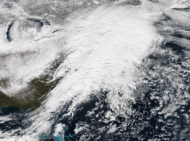
 Satellite image of the large winter storm moving off the East Coast early on February 2. Snow from the system can be seen on the left. | |
| Type |
Extratropical cyclone Winter storm Blizzard |
|---|---|
| Formed | January 29, 2015 |
| Dissipated | February 3, 2015 |
| Lowest pressure | 978 mb (28.88 inHg) |
| Maximum snowfall or ice accretion | 24.1 inches (61 cm) in Lunenburg, Massachusetts.[1] |
| Casualties | 15 |
| Areas affected | High Plains, Ohio Valley, Central United States, New England |
| Part of the 2014–15 North American winter | |
At the onset of February 2015, a major winter storm plowed through the majority of the country, dumping as much as 2 feet (24 in) of new snowfall across a path from Iowa to New England, as well as blizzard conditions. This winter storm came less than a week after another crippling blizzard which impacted the Northeast with 2–3 feet of snow.
Meteorological history
On January 30, an upper-level low moved ashore into California.[2] Pumping some moisture from the Pacific Ocean, it began to produce snow in the high mountainous terrains of New Mexico and Arizona. It began to dive southwards into Mexico late on January 31, and at the same time, a trough had dived southwards into the United States.[2] A surface area of low pressure developed as a result of this along an arctic front that was moving through the High Plains. Early on February 1, the winter storm began to move eastwards on a near 1,900-mile long path. Snowfall bands began to set up with rates of up to 2–3 inches (5.1–7.6 cm) per hour and strong winds, leading to blizzard conditions. The cities around the Chicago and Detroit areas were among the locations that got slammed the hardest by the blizzard. As the blizzard continued to move eastwards, winds continued to increase which resulted in higher snow drifts in some locations. The Northeast was its next target. Late on February 1, snow began to spread into parts of New York City and parts of New England.[2] The snow continued to gradually move eastwards until it had reached the southwestern parts of New England overnight. By now the area of low pressure had reached central Pennsylvania, with its warm front passing through New York City. Because of this, snowfall totals had a sharp cutoff of about 20 miles (32 km). Instead, NYC picked up about 4 inches (10 cm) and some freezing rain. As the area of low pressure moved off the coast early on February 2, it began to rapidly intensify, with warm air being thrown into coastal front, and stronger winds which resulted in blizzard conditions, heavier snowfall totals and snowfall rates of about 2–3 inches (5.1–7.6 cm) per hour.[2] As it continued to move to the east, the snow began to gradually taper off as snowbands pulled away, the system continued to intensify before peaking at 978 millibars (28.9 inHg) late on February 3,[3] and dissipating a day later.
Impact
Travel
The blizzard caused major travel headaches across the country.[2] Up to 3,000 flights were cancelled nationwide. Half of these came from the Chicago area which was especially hardest hit from the system.[2]
Snowfall reports
This is a list of the largest snowfall reports by state impacted by the storm. Source:[1]
- 22 inches (56 cm) near Ellsworth
- 17 inches (43 cm) near Bow
- 19 inches (48 cm) in Woodford
- 24.1 inches (61 cm) in Lunenburg
- 13.1 inches (33 cm) in West Glocester
- 14.3 inches (36 cm) in Weston
- 19.5 inches (50 cm) in Webster
- 12 inches (30 cm) in West Milford
- 13 inches (33 cm) in Cranesville
- 4 inches (10 cm) in Oakland
- 15.5 inches (39 cm) near Waterville
- 20 inches (51 cm) in Kalamazoo
- 19.6 inches (50 cm) near Plymouth
- 14 inches (36 cm) near Pleasant Prairie
- 22 inches (56 cm) near Lincolnshire
- 14.2 inches (36 cm) near Polk City
- 11 inches (28 cm) near Hurdland
- 5 inches (13 cm) in Albert Lea
- 10 inches (25 cm) in Pender
- 8 inches (20 cm) in Yankton
- 10 inches (25 cm) in Corning
- 8.2 inches (21 cm) near Louisville
- 15 inches (38 cm) near Los Alamos
- 6 inches (15 cm) in East Willow Creek
Records
References
- 1 2 "Winter Storm Linus Recap: Top 5 Snowstorm For Chicago, Detroit". The Weather Channel. February 3, 2015. Retrieved March 30, 2016.
- 1 2 3 4 5 6 7 8 http://www.wpc.ncep.noaa.gov/winter_storm_summaries/event_reviews/2015/Southwest_Northeast_WinterStorm_Jan2015.pdf
- ↑ "WPC Surface Analysis Archive". Retrieved 31 March 2016.